Top Qs
Timeline
Chat
Perspective
San Salvador (volcano)
Complex volcano in El Salvador From Wikipedia, the free encyclopedia

Remove ads
The San Salvador Volcano (also known as Quezaltepeque or El Boquerón) is a stratovolcano situated northwest to the city of San Salvador. The crater has been nearly filled with a relatively newer edifice, the Boquerón volcano. San Salvador is adjacent to the volcano and the western section of the city actually lies among its slopes. Due to this close proximity, any geological activity of the volcano, whether eruptive or not, has the potential to result in catastrophic destruction and death to the city. Despite this, the volcano is iconic of the city, and several TV and radio antennas are situated on the El Picacho peaks and the crater of Boqueron. El Picacho, the prominent peak is the highest elevation (1,960 metres altitude).
This article includes a list of references, related reading, or external links, but its sources remain unclear because it lacks inline citations. (December 2024) |
.jpg)

Remove ads
Boquerón edifice
Summarize
Perspective


The main edifice, known as the Boquerón edifice, formed between 700 and 1,000 years ago, filling up a former caldera. The crescent-shaped ridge on the northeast side of the volcano is a remnant of the caldera rim. The lavas of the Boquerón edifice contain more alkali elements and iron oxide than the lavas of the older edifice. Around 800 years ago, the present day crater was formed in a violent explosion. The crater, which gives it the present name (Boquerón means "big mouth" in Spanish) is 1.5 km in diameter and 500m deep. Within the crater around the upper walls, crops are cultivated by the locals who live on the volcano.
The magma chamber which the volcano sits upon contains a number of fissures which protrude along the flanks and sides of the volcano. The northwest (N40W) fissure has been the most active recently, with such significant eruptive events, such as the Loma Caldera eruption which buried the ancient village of Ceren and the eruption of El Playon (1658–71) which buried the town of Nexapa. The citizens relocated to Nejapa and nowadays the eruption is celebrated annually.
The most recent eruption in 1917 caused a flank eruption on the volcano along the N40W fissure. During this eruption, the crater lake inside the Boquerón evaporated and a cinder cone appeared, christened 'Boqueroncito'.
Remove ads
Gallery
 A 1914 postal, with the image of the lagoon in the crater of San Salvador Volcano, El Salvador. The lagoon disappeared when the volcano erupted in 1917
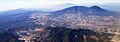 The massive San Salvador volcano dominates the landscape and skyline west of the city of San Salvador.
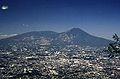 The massive compound San Salvador (volcano) dominates the landscape west of El Salvador's capital city of San Salvador.
 San Salvador skyline with the volcano behind it
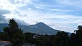 A view of San Salvador volcano.
 View of San Salvador Volcano from downtown San Salvador
 San Salvador Volcano from Cuscatlán Stadium
 San Salvador volcano towering over San Salvador city at night


Remove ads
See also
References
External links
Wikiwand - on
Seamless Wikipedia browsing. On steroids.
Remove ads