Top Qs
Timeline
Chat
Perspective
Los Alamitos, California
City in California, United States From Wikipedia, the free encyclopedia
Remove ads
Los Alamitos (lohs al-uh-MEE-tohs; Spanish for 'the little cottonwoods') is a city in Orange County, California. The city was incorporated in March 1960. The population was 11,780 at the 2020 census, up from 11,449 at the 2010 census.
This article may be too long to read and navigate comfortably. (July 2025) |
A significant area of the city is taken up by Joint Forces Training Base - Los Alamitos,[6] which also hosts the USA Water Polo National Aquatic Center.[7]
Remove ads
History
Summarize
Perspective
The Tongva inhabited this area before the city was formerly established. Rancho Los Alamitos specifically was previously known as the village of Puvunga. Although it is still a sacred land used by the Tongva people.[8]

An editor has launched a copyright investigation involving this section. The text under investigation is currently hidden from public view, but is accessible in the page history. Please do not remove this notice or restore blanked content until the issue is resolved by an administrator, copyright clerk, or volunteer response agent.
The purported copyright violation copies text from https://diaocthongthai.com/en/map-of-ca-los-alamitos/ ; as such, this page has been listed on the copyright problems page. Unless the copyright status of the text of this page or section is clarified and determined to be compatible with Wikipedia's content license, the problematic text and revisions or the entire page may be deleted one week after the time of its listing. What can I do to resolve the issue?
Steps to list an article at Wikipedia:Copyright problems:
|
This section is written like a personal reflection, personal essay, or argumentative essay that states a Wikipedia editor's personal feelings or presents an original argument about a topic. (February 2011) |
Remove ads
Geography
Summarize
Perspective
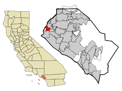
Los Alamitos is bounded by Cypress to the north and east, West Garden Grove to the east, and Seal Beach to the south. The census-designated place of Rossmoor is enclosed by Los Alamitos to the north, east, and west.[12] The city shares a northwestern border with Los Angeles County's Long Beach, namely the El Dorado Park neighborhood. Coyote Creek serves as a major geographical divider between Los Alamitos and Long Beach.
Biogeography
The most common native species: Hairy Sand Verbena, Red Sand Verbena, and Pink Sand Verbena.
Climate
Gardeners use several climate zone indicators to determine the proper plantings for an area. In the U.S. most plants and seeds are indicated for a particular climate by the USDA Hardiness Zone. A more exact measure is the Sunset zone. In Los Alamitos, the USDA Hardiness Zone is 9.[13] The Sunset climate zone is 22.[14]
Remove ads
Wikiwand - on
Seamless Wikipedia browsing. On steroids.
Remove ads


