Top Qs
Timeline
Chat
Perspective
Mabitac
Municipality in Laguna, Philippines From Wikipedia, the free encyclopedia
Remove ads
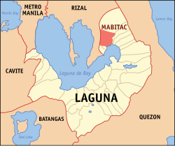
Mabitac, officially the Municipality of Mabitac (Tagalog: Bayan ng Mabitac), is a municipality in the province of Laguna, Philippines. According to the 2024 census, it has a population of 21,748 people.[5]
Remove ads
Etymology
Mabitac was an excellent hunting ground for wild game three centuries ago. Native hunters used numerous cave-ins or trap-ins called "bitag" in the local language. Hence, the place was referred to as "Mabitag" meaning "a place with many traps".
History
The first Spaniards who came to this place were the friars who established the first Spanish settlement in the area and began to Christianize the local population. The Spaniards, having difficulty in pronouncing the "G" consonant, called this place "Mabitac" whenever they mentioned this place. Eventually, the name found its way in the official records and maps of Laguna made by Spanish cartographers and mariners who chartered the coastal areas of Laguna de Bay.
This town was formerly a barrio of Siniloan, an immediate neighboring town. It became an independent municipality only in the year 1611, not by legislation, but by mutual agreement by and between the Spanish friars of both towns who were then the influential ruling class.
Mabitac was the site of a battle in the Philippine–American War, when on September 17, 1900, Filipinos under General Juan Cailles defeated an American force commanded by Colonel Benjamin F. Cheatham.
World War II and Japanese occupation

In 1942, Japanese soldiers entered and occupied Mabitac. In 1945, the Philippine guerrillas defeated the Japanese and liberated Mabitac.
Remove ads
Geography
Summarize
Perspective
Mabitac is 30 kilometres (19 mi) from Santa Cruz, 76 kilometres (47 mi) from Manila, and 59 kilometres (37 mi) from Antipolo.
Barangays
Mabitac is politically subdivided into 15 barangays, as indicated below: [6] Each barangay consists of puroks and some have sitios.

Climate
Demographics
In the 2020 census, the population of Mabitac was 21,275 people,[13] with a density of 260 inhabitants per square kilometre or 670 inhabitants per square mile.
Remove ads
Economy
Poverty incidence of Mabitac
10
20
30
40
2000
35.68
35.68
2003
24.42
24.42
2006
11.40
11.40
2009
14.43
14.43
2012
22.49
22.49
2015
16.91
16.91
2018
2.99
2.99
2021
9.79
9.79
Source: Philippine Statistics Authority[14][15][16][17][18][19][20][21]
Education
The Famy-Mabitac Schools District Office governs all educational institutions within the municipality. It oversees the management and operations of all private and public, from primary to secondary schools.[22]
Primary and elementary schools
- E.W. De Vela Elementary School
- Eugenia Games Olarte Reyes Elementary School
- Mabitac Elementary School
- Matalatala Elementary School
- Nanguma Elementary School
- Numero Elementary School
- Paagahan Elementary School
Secondary schools
- Mabitac National High School
- Paagahan Integrated National High School
- Matalatala Integrated National High School
Remove ads
Gallery
- Welcome marker
- Hilltop view of Mabitac
- Town hall
- Nuestra Señora de Candelaria Parish Church
Notable personalities
- Juan Cailles (born Juan Cailles y Kauppama; November 10, 1871 – June 28, 1951) was a Filipino of French-Indian descent. A member of the revolutionary movement Katipunan, he was a commanding officer of the Philippine Revolutionary Army who served during the Philippine Revolution and Philippine–American War. He later served as a provincial Governor of Laguna and a member of the Philippine Legislature.
Remove ads
See also
References
External links
Wikiwand - on
Seamless Wikipedia browsing. On steroids.
Remove ads


