Top Qs
Timeline
Chat
Perspective
Mahakam Ulu Regency
Regency in East Kalimantan, Indonesia From Wikipedia, the free encyclopedia
Remove ads
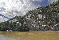
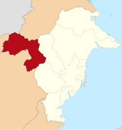
Mahakam Ulu Regency (Indonesian pronunciation: [maˈhakam ˈulu], lit. 'Upper Mahakam') is a regency (kabupaten) in the province of East Kalimantan, Indonesia. As the name implies, it comprises the upper valley of the Mahakam River. It covers an area of 18,427.81 km2. The regency was established on 14 December 2012, formed from the former northern districts of West Kutai Regency.[3] The districts now forming the regency held a combined population of 24,994 at the 2010 Census;[4] the population for the new regency at the 2020 Census was 32,513;[5] the official estimate as at mid 2024 was 39,319.[1] The administrative capital is at Ujoh Bilang, which had 5,218 inhabitants as at mid 2023.
Mahakam Ulu shares borders with Kapuas Hulu (West Kalimantan) to the west; Murung Raya, North Barito (Central Kalimantan), and West Kutai to the south, Kutai Kartanegara to the east, and Malinau to the north. It is also the only regency in East Kalimantan to share an international land border with the Malaysian state of Sarawak (Kapit), to the north. Mahakam Ulu is also notorious for being geographically isolated from the rest of East Kalimantan. As a result, the public services and transportation access are still minimal.[6]
Remove ads
Administrative districts

The regency is divided into five districts (kecamatan), tabulated below with their areas and their populations at the 2010 Census[4] and 2020 Census,[5] together with the official estimates as at mid 2023.[7] Notable settlements include the twin villages of Tiong Ohang and Tiong Bu'u in Long Apari District.[8] The table also includes the locations of the district administrative centres, the number of administrative villages (all classed as kampung or desa) in each district, and its post code.
Remove ads
References
Wikiwand - on
Seamless Wikipedia browsing. On steroids.
Remove ads


