Top Qs
Timeline
Chat
Perspective
Maheshpur Upazila
Upazila in Khulna, Bangladesh From Wikipedia, the free encyclopedia
Remove ads
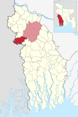
Maheshpur Upazila (Bengali: মহেশপুর উপজেলা) is a part of Jhenaidah District in Khulna Division, Bangladesh.[4]
Remove ads
History
The original name of Maheshpur Upazila, located on the banks of the Kapotaksha River, was Yogi Daha. Later, in 1701 (according to the Gregorian calendar), when a temple was established in the name of the Hindu god Maheshwar, the original name was changed to Maheshpur. Some say that the area was named Maheshpur after Mahishya King Mahesh Chandra. Another legend is that when the kingdom of that region came into the hands of a Kaivarta king "Mahesh", it was named Maheshpur after him. Maheshpur was a part of the Bangaon subdivision of India. In 1947, Maheshpur came under the Jhenaidah subdivision. Maheshpur was also called Khadya Bhandar or Ratna Bhandar for its abundance of agricultural wealth.[5]
Remove ads
Geography
Maheshpur Upazila has 12 unions, namely: SBK, Fotepur, Pantapara, Shoruppur, Shamkur, Nepa, Kajirber, Bashbaria, Jadoppur, Natima, Mandarbaria and Ajompur. Maheshpur (Town) consists of 9 wards and 14 mahallas. Maheshpur thana was turned into an upazila in 1983.
Maheshpur Upazila shares borders with North 24 Parganas district in West Bengal, India and Chaugachha upazila of Jessore district to the south, Nadia district of West Bengal, India to the west, Jibannagar Upazila of Chuadanga district to the north, and Kotchandpur upazila to the east.
The main river flowing through this upazila is the Kapotakkho Nod.
Maheshpur is located at 23.3500°N 88.9125°E. It has 79,761 households and total area 417.85 km2.
Remove ads
Demographics
As of the 2011 Census of Bangladesh, Maheshpur upazila had 79,761 households and a population of 332,514. 66,939 (20.13%) were under 10 years of age. Maheshpur had an average literacy rate of 44.79%, compared to the national average of 51.8%, and a sex ratio of 1,000 females per 1,000 males. 27,670 (8.32%) of the population lived in urban areas.[7][8]
The area of the town is 11.47 km2. The town has a population of 26,473; male 51.26% and female 48.74%;
Administration
Summarize
Perspective
Maheshpur Upazila is divided into Maheshpur Municipality and 12 union parishads: Azampur, Banshbaria, Fatepur, Jadabpur, Kazirber, Manderbaria, Natima, Nepa, Panthapara, S.B.K., Shyamkur, and Swaruppur. The union parishads are subdivided into 150 mouzas and 196 villages.[7]
Maheshpur Municipality is subdivided into 9 wards and 16 mahallas.[7]
Upazila Nirbahi Officer (UNO)
Members of Parliament (MP)
Upazila Porishad
Union Porishad
Remove ads
Education
Maheshpur also has the following educational institutions:
- Mohespur Govt. Degree College
- Bir Sherstha Shahid Hamidur Rahman Govt. College, Khalish Pur Bazar
- Moheshpur Mohila College
- Shohidul Islam degree college, Voiroba, Maheshpur, Jhenaidah
- Moheshpur Gov. Pilot Model High School, Maheshpur, Jhenaidah
- Moheshpur Pouro Laboratory High School, Moheshpur, Jhenaidah
- K.B.S. Secondary School, Kanchonpur, Maheshpur, Jhenaidah
- Samonta High School, Maheshpur, Jhenaidah.
- Samonta Dhakhil Madrasa, Maheshpur, Jhenaidah
- Voiroba Senior Madrasa, Voiroba, Maheshpur, Jhenaidah
- Khalishpur Secondary School, Khalishpur Bazar, Maheshpur, Jhenaidah
- Pragoti Biddiyaniketon, High School,Jadabpur, Moheshpur, Jhenaidah
Remove ads
Notable residents
- Hamidur Rahman, recipient of Bir Sreshtho (the highest military award of Bangladesh)[9][10]
See also
References
External links
Wikiwand - on
Seamless Wikipedia browsing. On steroids.
Remove ads

