Top Qs
Timeline
Chat
Perspective
Meherpur District
District of Bangladesh in Khulna From Wikipedia, the free encyclopedia
Remove ads
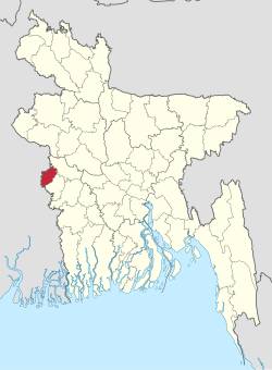
Meherpur District (Bengali: মেহেরপুর জেলা) is a northwestern district of Khulna Division in southwestern Bangladesh. It is bordered by West Bengal, India in the west, and by the Bangladeshi districts of Kushtia and Chuadanga to the east.[4] Pre-independence Meherpur was a subdivision of Nadia district.[5] The district has an area of 716.08 square kilometres (276.48 sq mi).
Remove ads
History
According to Ashraf Siddiqui, the district is named after the 16th century dervish Meher Ali Shah.
The Provisional Government of Bangladesh was formed and solemnly sworn in Meherpur's Baidyanathtala village (later renamed as Mujibnagar), on 17 April 1971 under the leadership of Tajuddin Ahmed and Syed Nazrul Islam. The entire Proclamation ceremony was organised by local leaders under the supervision of Momeen Chowdhury and MM Rustom Ali.[6] Meherpur became a district in 1983 under CMLA Hussain Muhammad Ershad's decentralization programme.[6]
Remove ads
Demographics
Summarize
Perspective
According to the 2022 Census of Bangladesh, Meherpur District had 195,322 households and a population of 705,356 with an average 3.59 people per household. Among the population, 104,284 (14.78%) inhabitants were under 10 years of age. The population density was 951 people per km2. Meherpur District had a literacy rate (age 7 and over) of 68.14%, compared to the national average of 74.80%, and a sex ratio of 1074 females per 1000 males. Approximately, 22.53% of the population lived in urban areas. The ethnic population was 161.[2]
In 2022, Muslims formed 97.87% of the population, Hindus 1.20%, and Christians 0.92%. Other religions were 0.01%.
Remove ads
Economy
Main sources of income: Agriculture 68.95%, non-agricultural labourer 3.24%, industry 0.87%, commerce 13.83%, transport and communication 2.21%, service 3.81%, construction 1.03%, religious service 0.14%, rent and remittance 0.59% and others 5.33%.[4]
See also
Notes
- Including Jainism, Christianity, Buddhism, Zoroastrianism, Judaism, Ad-Dharmis, or not stated
References
Wikiwand - on
Seamless Wikipedia browsing. On steroids.
Remove ads


