Top Qs
Timeline
Chat
Perspective
Melghat
Tiger reserve in India From Wikipedia, the free encyclopedia

Remove ads
Melghat was among the first nine tiger reserves of India to be notified in 1973 under Project Tiger. It is located in the northern part of Amravati District of Maharashtra. Melghat Wildlife Sanctuary was declared as in 1985. The total area of the reserve is 2,768 square kilometres.[1][2][3]
This article needs additional citations for verification. (March 2010) |


Remove ads
Geography
The Melghat area was declared a tiger reserve in 1974. Meghat Tiger Reserve is administratively divided into Sipna, Gugamal and Akot Wildlife Division. The total area of the reserve is around 2,768 km2 (1,069 sq mi).[4]
At the northern extreme of the Amravati district of Maharashtra, on the border of Madhya Pradesh, lies the Melghat in the South-western Satpura mountain ranges. Melghat means 'meeting of the ghats', which describes the area as a large tract of unending hills and ravines scarred by jagged cliffs and steep climbs. The Tapti River flows through the northern part of Melghat Tiger Reserve and forms the boundary of the reserve together with the Gawilghur ridge of the Satpura Range. The forest is tropical dry deciduous in nature, dominated by teak (Tectona grandis). The reserve is a catchment area for five major rivers: the Khandu, Khapra, Sipna, Gadga and Dolar. These all rivers are tributaries of the river Tapti.[citation needed]
Remove ads
Fauna
The fauna in Melghat includes several large animal species, such as Bengal tiger, Indian leopard, sloth bear, dhole, striped hyena, indian wolf, Indian jackal, sambar, gaur, barking deer, nilgai, chital, chausingha, honey badger, flying squirrel, wild boar, langur, rhesus monkey, indian porcupine, indian pangolin, mouse deer, python, smooth-coated otter and black-naped hare.[5][6][7]
Population
There are 61 villages in the reserve, all outside the core area.[citation needed] 22 are in the buffer zone and 39 in the Multiple Use Area (MUA).[citation needed] Human population in the buffer zone and MUA is 11024 and 15642, respectively, as per 1994 census.[citation needed]
The inhabitants are mainly tribal, largely of the Korku tribe (80 per cent) and others like Gond, Nihal, Balai, Gaolan, Gawali, Halbi, Wanjari, and Maratha. All inhabitants depend on the forest for bona fide domestic needs of firewood, timber, fodder, medicinal plants, and non-timber forest products like fruit, flowers, gum and medicinal plants. Their main source of income is from labor and rainy season agriculture. They augment their income by collecting non-timber forest products like mahuali, flowers, seeds, charoli, gumcula, dhawada, tendu-leaves, and musali (a medicinal plant).
 Lake in Melghat
 Teak forest in Melghat
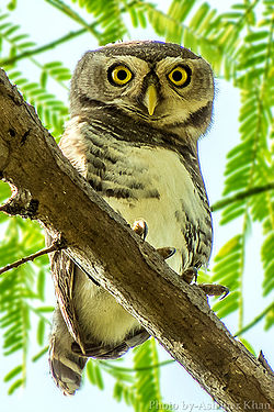 Melghat hosts the endangered forest owlet
 A tiger in Melghat

_Habitat_in_Melghat,_Maharashtra._Degraded_Teak_forest..jpg)


References
External links
Wikiwand - on
Seamless Wikipedia browsing. On steroids.
Remove ads