Top Qs
Timeline
Chat
Perspective
Merced Peak
Mountain in the American state of California From Wikipedia, the free encyclopedia

Remove ads
Merced Peak, with an elevation of 11,731 feet (3,576 m), is the highest point in the Clark Range,[1] just surpassing three other peaks; Red Peak (11,704 feet),[5] Gray Peak (11,578 feet),[6] and Mount Clark (11,527 feet).


Merced Peak is located close to southern border of Yosemite National Park, near the Ottoway Lakes. The summit can be approached from the Quartz Mountain Trailhead over Chiquito pass or from one of two trailheads on the road to Glacier Point.[7]
In 1871, influential Scottish-American naturalist John Muir discovered an active alpine glacier below Merced Peak, which helped his theory that Yosemite Valley was formed by glacial action gain acceptance.
Remove ads
Climate
Summarize
Perspective
According to the Köppen climate classification system, Merced Peak is located in an alpine climate zone.[8] Most weather fronts originate in the Pacific Ocean, and travel east toward the Sierra Nevada mountains. As fronts approach, they are forced upward by the peaks (orographic lift), causing moisture in the form of rain or snowfall to drop onto the range.
Remove ads
See also
Gallery
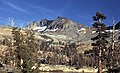 Merced Peak, west aspect
 Merced Peak seen from Ottoway Lake


References
External links
Wikiwand - on
Seamless Wikipedia browsing. On steroids.
Remove ads