Top Qs
Timeline
Chat
Perspective
Miami Rock Ridge
Geological formation in Florida, USA From Wikipedia, the free encyclopedia

Remove ads
The Miami Rock Ridge is an oolitic, continuous outcrop of limestone, part of the Miami Formation, which formerly covered a large extent of southernmost South Florida; as part of an ecosystem it formed portions of the Everglades. Rising 7 to 8.6 m (23 to 28 ft) above sea level, it ranges from northern Miami-Dade County—the approximate latitude of North Miami Beach—southward to the upper Florida Keys and southwestward into Everglades National Park, creating a karst-dominated landscape.[1] The ridge is of Late Pleistocene origin. A series of tidal channels, dubbed transverse glades, formed within valleys in the ridge and acted as outlets for freshwater from the Everglades, thereby modifying the estuarine environment of Biscayne Bay.[2][a] One of the few areas above pre-drainage sea level, the Miami Rock Ridge was heavily exploited for agriculture and real estate.[5][6]
Remove ads
Ecology
The coastal ridge was traditionally a component of the endangered pine rocklands, which grew upon its length.[7] Globally imperiled today, the environmental community consisted of a large, unbroken expanse of South Florida slash pines (Pinus elliottii var. densa), interspersed by tropical hardwood hammocks; related to the Bahamian pineyards, it also occupied the Florida Keys.[8][7] The communities of the Miami Rock Ridge are sustained by wildfires, including those caused by lightning strikes, which affect the vegetation and its associates, maintaining biodiversity,[9][10] with a 20% floristic endemism rate.[7] Climate and an often-marly substrate limit the growth of vegetation, such that a mature subtropical hammock on the ridge typically is no taller than 59 feet (18 m).[11][12] Development has largely removed the original communities, which have fragmented into tiny parts of their original range;[7] remnants include Vizcaya Museum and Gardens, Simpson Park Hammock, and Alice Wainwright Park, which form part of Brickell Hammock, underlain by a large oolite outcrop, Silver Bluff.[13][14][b]
Remove ads
Gallery
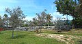 Miami Rock Ridge at Alice Wainwright Park
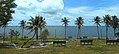 View of Biscayne Bay and Key Biscayne from atop the ridge
 General view of ridge from below


See also
- Arch Creek, Florida – Site of a natural arch in the Miami Rock Ridge
Notes
- One of these glades enclosed the Miami River, a section of which sported a 6-foot-2+1⁄2-inch (1.892 m) waterfall and 450-foot-long (140 m) rapids until 1908, when it was progressively bypassed by the Miami Canal and partly dredged.[3][4]
- Noted first by Bernard Romans in 1771, the bluff faced Biscayne Bay as a landmark; a freshwater spring, the Punch Bowl, once gushed nearby.[13][14]
Remove ads
References
Sources
Wikiwand - on
Seamless Wikipedia browsing. On steroids.
Remove ads