Top Qs
Timeline
Chat
Perspective
Mole Valley
Non-metropolitan district in England From Wikipedia, the free encyclopedia
Remove ads
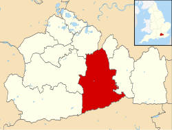
Mole Valley is a local government district in Surrey, England. Its council is based in Dorking, and the district's other town is Leatherhead. The largest villages are Ashtead, Fetcham and Great Bookham, in the northern third of the district.
Most of the district is on the escarpments of or adjoins the Surrey Hills, a designated Area of Outstanding Natural Beauty, which cover parts of the North Downs and Greensand Ridge, including locally Leith Hill, Polesden Lacey and Box Hill. Denbies Wine Estate, the largest vineyard in the country, is on the hills north-west of Dorking.[2] The Pilgrims' Way footpath runs along the North Downs. There are stations on the London–Worthing and Reading–Gatwick Airport railways, and in the northern third, a commuter stopping-service pattern line, London–Guildford (via Epsom) line.
The A24 road and the M25 motorway are the main thoroughfares and relative to London the incidence of car ownership is high. Between 2011 and its final iteration in 2019, the area hosted hill-focused sub-laps of the London–Surrey Classic cycling tour, an event established as preparation for the visit to Mole Valley of the 2012 Olympic Games Road Races.
The neighbouring districts are Epsom and Ewell, Reigate and Banstead, Crawley, Horsham, Waverley, Guildford, Elmbridge and Kingston upon Thames, the latter being a London borough.
Remove ads
History
The district was created on 1 April 1974 under the Local Government Act 1972, covering three former districts which were all abolished at the same time:[3][4]
- Dorking and Horley Rural District (except Horley and Salfords and Sidlow which went to Reigate and Banstead and parts of the parishes of Charlwood and Horley around Gatwick Airport which went to Crawley)
- Dorking Urban District
- Leatherhead Urban District
The new district was named after the River Mole, which flows through the area.[5]
Remove ads
Governance
- See main article: Mole Valley District Council
Towns and parishes
The former Leatherhead Urban District, which included Ashtead, Fetcham, Great Bookham and Little Bookham, is an unparished area, as is the majority of the former Dorking Urban District.[6][7]
The rest of the district is covered by civil parishes:[8][9]
Demographics
A Legatum Prosperity Index published by the Legatum Institute in October 2016 showed Mole Valley as the second most prosperous council area in the United Kingdom, after the nearby Borough of Waverley.[10]
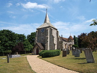
Churches graded II* or above


Remove ads
Emergency services
Mole Valley is served by these emergency services:
- Surrey Police. Dorking Police Station is the lead station in Mole Valley Division, Leatherhead Police Station is now closed.
- South East Coast Ambulance Service The district has two Ambulance Stations – one in North Holmwood (1 mile (2 km) south of Dorking), and the other in Leatherhead.
- Surrey Fire & Rescue Service, The district has two Fire Stations one in North Holmwood and the other in Leatherhead.
- SURSAR, The district is covered by Surrey Search & Rescue
- Hospital, Each town has a small NHS Hospital with no A&E. They are used for outpatients and rehabilitation.
Remove ads
Freedom of the District
- DMRC Headley Court received the Freedom of the District on 25 May 2010.[27]
See also
References
External links
Wikiwand - on
Seamless Wikipedia browsing. On steroids.
Remove ads


