Top Qs
Timeline
Chat
Perspective
Mount Cairnes (British Columbia)
Mountain in British Columbia, Canada From Wikipedia, the free encyclopedia

Remove ads
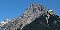
Mount Cairnes is a 3,060-metre (10,039 ft) mountain summit located in the Freshfield Ranges of the Canadian Rockies in British Columbia, Canada. The mountain is situated 44 km (27 mi) north of Golden in the Blaeberry Valley, 5.5 km (3.4 mi) east-northeast of Mount Mummery, and 3 km (1.9 mi) from the Continental Divide. The mountain was named in 1917 after noted geologist Delorme Donaldson Cairnes (1879-1917) of the Geological Survey of Canada from 1905 through 1917.[1][5] The mountain's name was officially adopted March 31, 1924, when approved by the Geographical Names Board of Canada.[4] There is also another Mount Cairnes named for this same person located in Yukon, where he did much of his work.


Remove ads
Climate
Based on the Köppen climate classification, Mount Cairnes is located in a subarctic climate with cold, snowy winters, and mild summers.[6] Winter temperatures can drop below −20 °C (−4 °F) with wind chill factors below −30 °C (−22 °F). Precipitation runoff from the mountain drains into Blaeberry River which is a tributary of the Columbia River.
Gallery
 The south ridge of Cairnes

See also
References
External links
Wikiwand - on
Seamless Wikipedia browsing. On steroids.
Remove ads