Top Qs
Timeline
Chat
Perspective
Mount Kaimon
Volcano on the island of Kyushu, Japan From Wikipedia, the free encyclopedia

Remove ads
Kaimondake (開聞岳, Kaimon-dake), or Mount Kaimon, is an undissected[i] volcano – consisting of a basal stratovolcano and a small complex central lava dome[2] – which rises to a height of 924 metres above sea level near the city of Ibusuki in southern Kyūshū, Japan. The last eruption occurred in the year 885 CE. Because of its conic shape, Mt. Kaimon is sometimes referred to as "the Fuji of Satsuma". It is one of the 100 Famous Japanese Mountains.

Remove ads
Geography
Summarize
Perspective
Mt. Kaimon is located in the south of Kagoshima prefecture, Kyushu and is an important reference point for marine traffic because it is the southernmost prominence of the Satsuma Peninsula. This is one entrance marker to Kinko Bay (Kagoshima Bay) complimentary to the Ōsumi Peninsula. Together with Mt. Noma and Mt. Kinpo,[citation needed] it is used by marine traffic.
Geology
Part of the Ibusuki volcanic field, Mt. Kaimon defines the eastern margin of the old Ata Caldera. The total eruptive volume of tephra has been 3.1 km3 (0.74 cu mi) and 2.3 km3 (0.55 cu mi) of lava.[3]


There is a sea scarp which is 7.8 km wide and 9.3 km long, the shape is similar to a horseshoe in the seabed at the southern foot of the mountain. There is a lot of sediment at the foot of the mountain due to submarine landslides. It was found that there is a sea scarp underground on the south side of the mountain and it was caused by pressure from a submarine landslide before Mt. Kaimon was formed. [citation needed]
The sedimentary layer of ejecta from the eruption at the end of the 7th century is called ao-kora (ao means blue and kora is soil consisting of volcanic ash found in the southern part of the Satsuma Peninsula). The sedimentary layer of ejecta by the eruption at the end of the 7th century is called murasaki-kora (Murasaki means purple). These layers are a clue to know the changes in life in this era. It has become clear that a village was isolated by a large eruption with change in life style in the latter part of the 9th century. [citation needed]
Eruptive history
Mount Kaimon began volcanic activity about 4,000 years ago. From 3,000 years up to 885 years ago, large eruptions occurred 9 times and eruptions resulting in large amounts of lava occurred 10 times making twelve major eruptions to date.[3]
The two large eruptions in the historic written record are in 874 CE (Jogan era) and 885 CE (Nin-na era)[2] The complex layered central dome consists of a scoria cone topped by lava flows and ultimately a lava dome which was penetrated by a plug.[3] However the explosion crater at the top was last enlarged by the 885 CE eruption.[3]
Transition of height
In 1895, the official height of Mt. Kaimon was 922.23 m (3,025.7 ft) from a second triangulation point which was at the summit of the mountain, but this was updated to 924 m (3,031 ft) by the Geospatial Information Authority of Japan in July 2001, because climbers pointed out that the height of the rocks on the top of the mountain were higher than the triangulation point.[4][citation needed]
Remove ads
Climbing
The spiral-shaped hiking trail climb of Mt. Kaimon takes about 3 hours. Mt. Kaimon is considerably lower than most of the mountains on the 100 famous Japanese Mountains list but as climbing starts from close to sea level there is an ascent of 900 metres (3,000 ft). Mt. Kaimon is a single peak but with summit rocky outcrops that allow views on all sides, such as Lake Ikeda to the north and the Pacific Ocean to the south.
 The eighth station of Mt. Kaimon ("station" is unit of itinerary of climbing from the base to the top. Regardless mountain height, all itineraries are divided into 10.)
 Ladder directly beneath the summit
 The summit of Mt. Kaimon with Lake Ikeda in the background
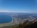 Maehara coast and Lake Ikeda from the summit
 Nagasakibana from the summit

.jpg)


Remove ads
Tourism
- Kaimon Sanroku Nature Park – The Tokara horse is breed at the base of the mountain.[5]
- Kaimon Sanroku Fureai Park – There are log houses as well as camp sites.[6]
- Hirasaki Shrine
- Lake Ikeda – It is said that a mystery creature "Issie" lives there. The rape mustard flowering in January is very attractive.[7]
- Bohi Park – Memorial to those killed in the Pacific War in the Philippines.
See also
References
External links
Wikiwand - on
Seamless Wikipedia browsing. On steroids.
Remove ads