Top Qs
Timeline
Chat
Perspective
Mount Tupper
Mountain in British Columbia, Canada From Wikipedia, the free encyclopedia

Remove ads
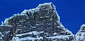
Mount Tupper 2,804 m (9,199 ft) is a mountain about 37 kilometres (23 mi) west of Golden, British Columbia, Canada and three kilometres east of Rogers Pass in Glacier National Park. Part of the Selkirk Mountains, it was formerly named Hermit Mountain until renamed (1887) in honour of Sir Charles Tupper when he was minister of Railways and Canals in Sir John A. Macdonald's cabinet during the siting and construction of the CPR line through the Selkirk Mountains, and later Prime Minister.[2]


Remove ads
Raspberry Rising Cave
In 2013, the mountain was the scene of cave explorations by a team of eight, led by Nicholaus Vieira and funded by the Royal Canadian Geographical Society, who followed the Raspberry Rising cave system for nearly a kilometre, climbing two waterfalls and traversing four sumps. The end of the cave was not reached and further explorations are planned.[3][4]
Climate
Based on the Köppen climate classification, Mount Tupper is located in a subarctic climate zone with cold, snowy winters, and mild summers.[5] Temperatures can drop below −20 °C with wind chill factors below −30 °C. Precipitation runoff from the mountain drains into the Beaver River which is a tributary of the Columbia River.
Gallery
 Mount Tupper in winter

See also
References
External links
Wikiwand - on
Seamless Wikipedia browsing. On steroids.
Remove ads