Top Qs
Timeline
Chat
Perspective
Mu Ko Ang Thong National Park
Marine protected area in Surat Thani Province of Thailand From Wikipedia, the free encyclopedia

Remove ads
Mu Ko Ang Thong is a marine national park in the Gulf of Thailand in Surat Thani Province.[2] It covers 42 islands in a total area of 63,750 rai ~ 102 square kilometres (39 sq mi),[3] of which about 50 square kilometres (19 sq mi) are land and the rest is water. The park was established on 12 November 1980.[4] The northern tip of Ko Phaluai is also part of the marine park. There is a ranger station, bungalows, a shop, and a restaurant at Ao Phi Beach on Ko Wua Talap.
This article needs additional citations for verification. (January 2018) |


The name "Ang Thong" (Thai: อ่างทอง) means 'bowl of gold'. "Mu Ko" (หมู่เกาะ) simply means 'group of islands'.
Since 2002 the park has been registered as Ramsar site number 1184.[4]
Remove ads
Topography
Mu Ko Ang Thong is a national park located in shallow water near the shore. The average water depth is about 10 m (33 ft). [5]
Islands
Remove ads
Gallery
 Ang Thong National Park from Ko Wua Talab
 Beach, Ko Mae Ko
 Beach, Ko Wua Talab
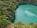 Laguna, Ko Mae Ko
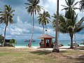 Ranger station
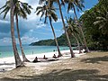 Beach
Beach Ko Wua Talab


See also
References
External links
Wikiwand - on
Seamless Wikipedia browsing. On steroids.
Remove ads