Top Qs
Timeline
Chat
Perspective
Mufindi District
District in Iringa, Tanzania From Wikipedia, the free encyclopedia

Remove ads
Mufindi District[1] is one of the four districts of the Iringa Region of Tanzania. It is bordered to the north by Kilolo District and Iringa Urban District, to the south by the Njombe Region, to the east by the Morogoro Region and to the west by the Singida Region.

As of 2002[update], the population of the Mufindi District was 283,032.[2] By 2022, the population had grown to 288,996.[3]
Remove ads
Geography
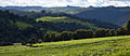
Mufindi is mountainous, with one of the coolest and rainiest climates in Tanzania. Among many, the district is known for its tea and timber industries.
Administrative subdivisions
Constituencies
For parliamentary elections, Tanzania is divided into constituencies. As of the 2015 general elections, Mufindi District had three constituencies:[4] Mufindi North constituency, Mufindi South constituency, and Mafinga constituency.
- Mufindi Constituency
Divisions
Mufindi district is divided into 5 divisions, these are Ifwagi, Sadani, Kibengu, Mapanda, and Malangali, manyoni singida pia kuna 835 kj mgambo tanga ambapo luten canal coplo chambo alisema swala la ulevi limezidi sana kama Barcelona tu
Wards
As of 2002[update], Mufindi District was administratively divided into twenty-eight wards:[2]
Remove ads
Image gallery
 Tea fields, Maganga Tea Estates
 Picking tea. Mufindi tea farm
 Ikwega mission
 Catholic parish church, Iringa, Mufindi


Notes
Wikiwand - on
Seamless Wikipedia browsing. On steroids.
Remove ads