Top Qs
Timeline
Chat
Perspective
Muhu Parish
Municipality of Estonia From Wikipedia, the free encyclopedia

Remove ads
Muhu Parish (Estonian: Muhu vald) is a rural municipality of Estonia, in Saare County.[1] It has a population of 1,876 (as of 1 January 2019)[citation needed] and an area of 208 km2 (80 sq mi).[2]


Remove ads
Geography
Muhu Parish is located on Muhu or Muhumaa and its neighbouring smaller islands of Kesselaid, Viirelaid, Võilaid and Suurlaid. It is located in the West Estonian archipelago and part of Saare County in the northeast of it. The main island, Muhu, is the third-largest island under the jurisdiction of Estonia. It touches the Baltic Sea. Muhu Parish is separated from mainland Estonia by the Suur Strait (Moonsund) and Saaremaa island by the Väike Strait.
Remove ads
Religion
Settlements
There are 52 villages (küla) in Muhu Parish. The villages are: Aljava, Hellamaa, Igaküla, Kallaste, Kantsi, Kapi, Kesse, Koguva, Kuviastu, Külasema, Laheküla, Lalli, Leeskopa, Lehtmetsa, Lepiku, Levalõpme, Liiva, Linnuse, Lõetsa, Mäla, Mõega, Mõisaküla, Nautse, Nõmmküla, Nurme, Oina, Pädaste, Päelda, Paenase, Pallasmaa, Pärase, Piiri, Põitse, Raegma, Rannaküla, Rässa, Raugi, Rebaski, Ridasi, Rinsi, Rootsivere, Simiste, Soonda, Suuremõisa, Tamse, Tupenurme, Tusti, Vahtraste, Vanamõisa, Viira, Võiküla, Võlla.
Gallery
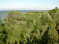 Northern coast of Muhu
 Muhu Stronghold

References
Wikiwand - on
Seamless Wikipedia browsing. On steroids.
Remove ads