Top Qs
Timeline
Chat
Perspective
Mukim Bukit Sawat
Mukim of Brunei From Wikipedia, the free encyclopedia
Remove ads
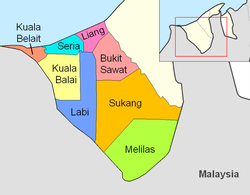
Mukim Bukit Sawat is a mukim in Belait District, Brunei.[3] It had a population of 794 in 2016.[4]
Geography
The mukim is located in the east of Belait District, bordering Mukim Telisai, Mukim Ukong and Mukim Rambai of Tutong District to the north, north-east and east respectively, Mukim Sukang to the south, Mukim Labi to the west and Mukim Liang to the north-west.[citation needed]
The mukim is named after Kampong Bukit Sawat, one of the villages it encompasses.
Demographics
As of the 2016 census,[4] the population was 794 with 57.1% males and 42.9% females. The mukim had 220 households occupying 220 dwellings. The entire population lived in rural areas.
Administration
As of 2021, the mukim comprised the following villages:
Facilities
Schools
The primary schools (sekolah rendah) in the mukim include:
- Merangking Primary School
- Orang Kaya Pemancha Berandai Primary School, Bukit Sawat — initially established as a Malay school and built in 1932.[6] A newer building was inaugurated on 28 August 1971 to replace the older building.[6]
Each school also houses a sekolah ugama (school for the country's Islamic religious primary education).
Mosques

- Al-Mashor Mosque, Kampong Sungai Mau — inaugurated by the then Prince Al-Muhtadee Billah on 28 February 1992; it can accommodate 200 worshippers.[7]
- Balai Ibadat Kampong Merangking
- Kampong Bukit Sawat Mosque — built in 1990 and can accommodate 120 worshippers.[8]
Tourism and recreation
- Sungai Mau Recreation Park — a recreation park in Kampong Sungai Mau[9]
Remove ads
References
Wikiwand - on
Seamless Wikipedia browsing. On steroids.
Remove ads


