Top Qs
Timeline
Chat
Perspective
Mushkpuri Top
Mountain in Khyber Pakhtunkhwa, Pakistan From Wikipedia, the free encyclopedia

Remove ads
Mushkpuri Top (Urdu: مُشکپوری) is a 2,800-metre-high (9,200 ft) mountain[1][2] in the Nathia Gali Hills, in the Circle Bakote Region of Abbottabad District of the Khyber Pakhtunkhwa province in northern Pakistan. It is 90 kilometres (56 mi) north of Islamabad, just above Dunga Gali in the Nathia Gali area of Ayubia National Park.[3] It is the second highest peak in the Galyat Region after Miranjani which is located at 2,992 metres (9,816 ft).[4] Much of the mountain is covered with Western Himalayan subalpine conifer forests.[5][6] In 1858 following a survey carried out during the British Raj it was described as being "clothed with deodar to its summit, and pines, firs, oaks, rhododendrons, walnuts, and other forest trees."[7]


Remove ads
The peak
The route from Nathia Gali on western side of mountain is a steady and 4-kilometre-long (2.5 mi) climb.[8] The mountain also has a route on the Dunga Gali side, with a steeper slope. There is a bird sanctuary on this side created with the help of the European Union.[9]
From the top of Mushkpuri peak, on the eastern edge of Khyber Pakhtunkhwa, the following areas can be seen: — Circle Bakote, Abbottabad University of Science and Technology, Jhelum River, the Bagh District of Azad Kashmir, in the south the city of Murree and the Murree Tehsil, as well as Islamabad.[10]
Remove ads
Gallery
 Mushkpuri mountain and the Nathia Gali in Ayubia National Park
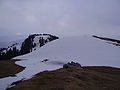 The top of Mushkpuri peak
 View from Mushkpuri
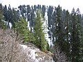 Conifer forests on the mountain.
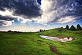 Mushkpuri Top


See also
- List of mountains in Pakistan
- Galyat region - the local region and its towns
- Muree - adjacent in the Murree District
References
Wikiwand - on
Seamless Wikipedia browsing. On steroids.
Remove ads