Top Qs
Timeline
Chat
Perspective
Naissaar
Island in Estonia From Wikipedia, the free encyclopedia

Remove ads
Naissaar (Swedish: Nargö; German: Nargen) is an island in Estonia. It is located in the Gulf of Finland of the Baltic Sea, northwest of the capital city Tallinn, and is administratively part of Viimsi Parish. The island has an area of 18.6 square kilometres (7.2 square miles). It is 8 kilometres (5.0 miles) long and 3.5 kilometres (2.2 miles) wide, and lies about 8.5 kilometres (5.3 miles) from the mainland.

.png)

The highest point on the island is Kunilamägi, which is 27 metres (89 feet) above sea level. The island consists predominantly of coniferous forest and piles of glacial erratic rocks and boulders. As of 2020, the island had a permanent population of 17; in addition to several dozen seasonal "summer residents".
From the 13th until mid-20th century, the island's three villages had a population of several hundred, mostly Estonian-Swedish fishermen and farmers. However, the majority of the indigenous population was evacuated during World War II. During the 1944–1991 Soviet occupation, Naissaar was a military base and off-limits to the civilian public.
In the 21st century, many of the old small houses of the Swedish villages have been restored, as well as an old narrow gauge military railroad that runs from the north to the southern tip of the island.
A notable native of the island was Bernhard Schmidt, an Estonian optician who invented the Schmidt telescope in 1930.
Remove ads
Lighthouse
The Naissaar Lighthouse was first built in 1788, although the present lighthouse dates to 1960. It is 47 meters tall.
History
Summarize
Perspective
A traditional, possibly folk etymology of the name is Nais-saar, roughly translating as 'woman island' in the Estonian language. It is possible that Naissaar is the island the chronicle of Adam of Bremen mentioned circa 1075 under the name Terra Feminarum. Swedish-speaking fishermen were well established on the island by the 15th century. The Kingdom of Sweden erected a small fortress on the island in 1705 during the Great Northern War. Naissaar as well as mainland Estonia were conquered by the Tsardom of Russia in 1710, and became part of the Russian Empire in 1721. The tsar had a new fortress with five bastions built in 1720s for the defense of Tallinn and Saint Petersburg, the new capital of Russia.
The main fortifications are from the period of Russian rule before World War I.
A single-ship action took place off the north end of the island on 23 June [O.S. 11 June] 1808, when the 14-gun Russian cutter Opyt fought unsuccessfully against the British 44-gun frigate HMS Salsette.
In 1850, the island's population was 155 people, and by 1858 it had grown to 188, most of whom were Estonian Swedes. Between 1853 and 1856, the inhabitants built a new chapel that was part of the Swedish parish of St. Michael in Tallinn.
In the early twentieth century, Russia began modernizing its fortifications in the Gulf of Finland. However, the outbreak of the First World War stopped the planned improvements for Naissaar. Nonetheless, in 1914 the Russian military opened a narrow-gauge railway line, with a total trackage of 37.7 km.
During the 1917 February Revolution the Russian battleship Petropavlovsk was based at Naissaar (which had been emptied of most of its inhabitants in 1914) during World War I, stationing 80 to 90 sailors there.[1] After the 1917 October Revolution the a local Council of Workers and Soldiers convened on Naissaar, declaring the local People's Commissar Council on 17 December, which included the Commissioner for War, Home Affairs, Labor, Finance and Health; they were later joined by an Education Commissioner. [2] The Council declared: "In constitutional terms, Naissaar has been designed to be an independent Soviet republic", naming it the "Soviet Republic of Soldiers and Fortress-Builders of Naissaar" (in Russian: Советская республика матросов и строителей острова Нарген; or the Free Island of Naissaar, Вольный Остров Нарген)[3] The Council, or government of the "republic", began drafting a constitution. It also intended to issue its own money, but the name of the units is unknown.[2] However, before the German forces occupied the island on 26 February 1918, the Soviet Russian fleet evacuated the republican government and all other sailors to Helsinki and then to Kronstadt, and the "republic" ceased to exist.[2]
After the capitulation of the German Empire at the end of World War I, the German occupiers handed over the rule of Naissaar to the government of newly independent Republic of Estonia on 19 November 1918. The Estonian government allowed the local population to return, and later also created a small naval base on Naissaar. In 1934, 450 people lived on the island, of whom 291 were Estonians, most of whom in turn were in the Estonian army. The Estonian army continued to use the Naissaar railway for military purposes throughout the 1930s.
During World War II, the Soviet Army occupied Naissaar in June 1940, only to have the German Wehrmacht displace it a few months later, in the summer of 1941. When the Red Army reinvaded Estonia in 1944, all of remaining Swedish-speaking fishermen of Naissaar evacuated, most of them took refuge in Sweden.
After the war, under the Soviet rule, Naissaar was officially a military zone and off-limits to the civilian public. Administratively, the settlement on the entire island were combined into a single village called Naissaare.
The Soviet Union established its largest factory for naval mines in the island. When the former Soviet, now Russian, military forces left Naissaar in 1993, they burned the explosives in the naval mines, leaving a multitude of metal casings scattered throughout the island. Many of these were later used as scrap iron; a field of mines is still visible near the wharf at Mädasadam. In several parts of Naissaar, the former Soviet military and arms industry contaminated the soil with oil and heavy metals.
After Estonia regained independence in 1991, and gained full control of the island in 1993, Naissaar was administratively re-divided into the three historical villages of Lõunaküla (Storbyn), Tagaküla (Bakbyn), and Väikeheinamaa (Lillängin) in 2011.[4] The Naissaar Museum, about the military history of the island, was opened in Lõunaküla.[5]
In 1995, Naissaar Landscape Conservation Area was established, covering the entire area of the island.
Remove ads
Gallery
 View of Kunilamägi hill in Naissaar, highest point of the island
 A village on Naissaar, painting by Julius von Klever (1881)
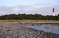 Naissaare lighthouse
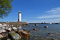 Naissaare harbour light beacon
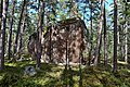 Põlendikukivi is the largest glacial erratic on the island
 Memorial stone in cemetery
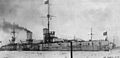 Russian battleship Petropavlovsk was stationed by Naissaar in 1917
 Emptied shells of old naval mines, made in the former Soviet Union
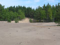
 South coast of Naissaar
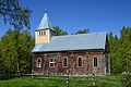 Naissaare church


Citations
External links
Wikiwand - on
Seamless Wikipedia browsing. On steroids.
Remove ads