Top Qs
Timeline
Chat
Perspective
Naldurg
Town in Maharashtra, India From Wikipedia, the free encyclopedia
Remove ads
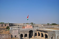
Naldurg is a historic city and municipal council located in the Dharashiv district of the state of Maharashtra, India. It is known for its prominent Naldurg Fort, one of the most impressive medieval forts in the region, built during the Bahmani and Adil Shahi periods. Situated near the confluence of the Bori river, Naldurg holds strategic and historical significance due to its fortifications, architecture, and cultural heritage. The city serves as a local administrative and commercial hub, with agriculture and small-scale industries forming the backbone of its economy. It is well-connected to major cities like Solapur and Dharashiv through road networks.
This article has multiple issues. Please help improve it or discuss these issues on the talk page. (Learn how and when to remove these messages)
|
Remove ads
Geography
Naldurg is located at 17.82°N 76.3°E, 438 km from Mumbai.50 km from Solapur city[2] It has an area of 7550 km2 and average elevation of 566 metres (1856 feet). The temperature ranges from 10.1 °C to 43.1 °C, and the average yearly rainfall is 760mm.
Demographics
As of 2011[update] India census,[3] Naldurg had a population of 18,341. Males constitute 52% of the population and females 48%. Naldurg has an average literacy rate of 84.10%, higher than the state average of 82.34%. Male literacy is 90%, and female literacy is 78%. In Naldurg, 15% of the population is under 6 years of age.[1] Schedule Caste (SC) constitutes 11.61% while Schedule Tribe (ST) were 0.95% of total population in Naldurg.[1]
Remove ads
See also
References
Wikiwand - on
Seamless Wikipedia browsing. On steroids.
Remove ads


