Top Qs
Timeline
Chat
Perspective
Nawabshah
City in Sindh, Pakistan From Wikipedia, the free encyclopedia
Remove ads
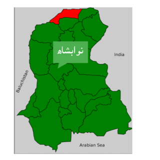
Nawabshah[a] is a headquarter of Nawabshah Tehsil in Shaheed Benazirabad District of Sindh province, Pakistan.[2] This city is situated in the middle of Sindh province. It is the 27th most populous city in Pakistan. Nawabshah is called the heart of Sindh Province.

Remove ads
History
18th–19th century CE
Nawabshah lies near the Indus River in central Sindh, long inhabited since the Indus Valley era.[3] Archaeological surveys note prehistoric and Harappan remains in the area, and the region later passed under various Muslim dynasties.[3] In particular, the 18th–19th-century Kalhora and Talpur dynasties left many mosques and tombs with characteristic Sindhi and Islamic architecture.[3]
British Raj
Under British rule, Nawabshah was carved out of Hyderabad District. Its taluka (subdivision) was established in 1903, and on 1 November 1912, Nawabshah was upgraded to full district status in Sindh.[2] The town was named for Syed Nawab Shah, a local landowner who migrated there in 1881, his family donated land of 60 acres for colonial-era district offices, and in recognition of this generosity, the British named the town after him.
After independence of 1947
After 1947, Nawabshah became part of independent Pakistan. In 2008, the district was officially renamed Shaheed Benazirabad in memory of Benazir Bhutto. In recent years, the city has grown rapidly.[2]
Remove ads
Demographics
Population
According to 2023 census, Nawabshah had a population of 363,138. Nawabshah is inhabited by various communities and tribes. The region's electoral politics have traditionally been shaped by these influential families, often with the support of smaller local communities.[2]
Languages
Area and population 2014
| Area[5][6] | 4,239 square km |
| Population | 1,435,130 |
| Male | 749,275 |
| Female | 685,855 |
| Population (below 15 Years) | 45% |
| Population (between 15 and 65 years) | 52.2% |
| Muslim population | 94.1% |
| Hindu population | 4.2% |
Remove ads
Climate
Summarize
Perspective
Nawabshah has a hot desert climate (Köppen climate classification BWh), narrowly missing a hot semi arid climate. The city is considered one of the hottest cities in Pakistan, with summer temperatures soaring as high as 53 °C or 127.4 °F. Temperatures above 45 °C or 113 °F are fairly common during late May and June. Winters start late, around mid-November, lasting to around mid-February, with night-time temperatures often reaching 4 °C or 39.2 °F, and temperatures below 0 °C or 32 °F occurring two or three times on average in January.
The highest temperatures each year in Pakistan, typically rising to above 50 °C (122 °F), are usually recorded in Nawabshah District and Sibi from May to August. The climate is generally dry and hot, but sometimes the temperature falls to 0 °C (32 °F). On 26 May 2010 record breaking severe heat wave hit the city and the mercury level reached 52 °C (126 °F) which was the highest temperature ever recorded in Nawabshah at the time.[7] The climate is generally dry and hot, but sometimes the temperature falls to 0 °C (32 °F). On 7 January 2011, temperatures dropped to 4 °C (39 °F) in the city.[8] The highest annual rainfall ever is 685 mm, recorded in 2022.
Remove ads
Major education institutes
Educational institutions in the city include:
- Bakhtawar Cadet College For Girls Shaheed Benazirabad[12]
- Nuclear Medicine Oncology & Radiotherapy Institute Nawabshah
- People's University of Medical & Health Sciences for Women[13]
- Quaid-e-Azam Law College Nawabshah
- Quaid-e-Awam University of Engineering, Science & Technology
- Shaheed Benazir Bhutto University of Veterinary and Animal Sciences[14]
- Shaheed Benazir Bhutto University, Sheringal[15]
Remove ads
Sports locations
Notes
See also
References
External links
Wikiwand - on
Seamless Wikipedia browsing. On steroids.
Remove ads


