Top Qs
Timeline
Chat
Perspective
New Zealand Subantarctic Islands
Southernmost parts of the South Pacific country From Wikipedia, the free encyclopedia
Remove ads
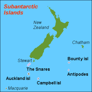
The New Zealand Subantarctic Islands comprise the five southernmost groups of the New Zealand outlying islands. They are collectively designated as a UNESCO World Heritage Site.[2]
This article needs additional citations for verification. (April 2009) |
Most of the islands lie near the southeast edge of the largely submerged continent centred on New Zealand called Zealandia, which was riven from Australia 60–85 million years ago, and from Antarctica 85–130 million years ago. They share some features with Australia's Macquarie Island to the west.
Remove ads
History
Summarize
Perspective
These islands were uninhabited at the time of European discovery, nonetheless, there is evidence of Māori and/or Polynesian visits to some of the island groups, and some were still known to Māori at the time of European contact.
- Antipodes Islands – Claims of a pottery shard found here in 1886, although this is contested.[3][4]
- Auckland Islands – Traces of Polynesian settlement, possibly dating to the 13th century, have been found by archaeologists on Enderby Island.[5][6] This is the most southerly settlement by Polynesians yet known.[7]
- Snares Islands – The islands were already known to the Māori, who called one of the larger islands Te Taniwha ("The sea-monster"). They are visible from near Stewart Island in good conditions.
European exploration took place in the 19th century, often involving exploiting the natural resources of the area for sealing and whaling etc. Some shipwrecks took place in the region, with crews being forced to live off the land. Hardwicke on Auckland Island represents one of the few serious attempts by whites to set up a settlement in the islands, subsequently abandoned.
Until 1995, scientific research staff were stationed permanently at a meteorological station on Campbell Island. Since then, the islands have been uninhabited, though they are periodically visited by researchers and tourists. Protection of reserves was strengthened in 2014, becoming the largest natural sanctuary in the nation.[8]
Remove ads
Islands
- Antipodes Islands
- Antipodes Island, Bollons Island, the Windward Islands, Orde Lees Island, Leeward Island, South Islet
- Auckland Islands
- Auckland Island, Adams Island, Disappointment Island, Enderby Island, Ewing Island, Rose Island
- Bounty Islands
- Main Group, Centre Group, and Eastern Group islets
- Campbell Islands
- Campbell Island / Motu Ihupuku, Dent Island, Folly Island, Jacquemart Island
- Snares Islands / Tini Heke
- Alert Stack, Broughton Island, High Island, North East Island, Western Chain islets
Territorial claims
New Zealand also has territorial claims, held in abeyance under the Antarctic Treaty System, over several islands close to the Antarctic mainland, including:
- Ross Island and the rest of the Ross Archipelago
- Balleny Islands: Young Island, Buckle Island, Sturge Island, plus several smaller islets
- Roosevelt Island
- Scott Island and Haggits Pillar
Of these, Ross Island is inhabited by the scientific staff of several research stations, notably at McMurdo Sound and Scott Base.
Remove ads
Ecology
The Antipodes, Auckland, Bounty and Campbell Islands are collectively designated the Antipodean Islands in the World Geographical Scheme for Recording Plant Distributions. The Snares Islands / Tini Heke are included with the South Island in New Zealand South under the scheme.
See also
- List of Antarctic and subantarctic islands
- List of islands of New Zealand
- Macquarie Island, an Australian administered island which neighbours these islands.
References
External links
Wikiwand - on
Seamless Wikipedia browsing. On steroids.
Remove ads

