Top Qs
Timeline
Chat
Perspective
Nitra Region
Region of Slovakia From Wikipedia, the free encyclopedia

Remove ads
The Nitra Region (Slovak: Nitriansky kraj, pronounced [ˈɲitrɪɐnski ˈkraj]; Hungarian: Nyitrai kerület) is one of the administrative regions of Slovakia. It was first established in 1923 and from 1996 exists in its present borders. It consists of seven districts (okres) and 354 municipalities, of which 16 have a town status. The economy of the region focuses more on agriculture, than in other Slovak regions. Nitra is its seat, largest city, and cultural and economic center.


.jpg)


Remove ads
Geography
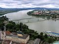
This region with a long history is situated in the southwest of Slovakia, mostly in the eastern part of the Danubian Lowland. It is divided into two sub-units: the Danubian Flat in the south-west, with eastern part of the Žitný ostrov island, and the Danubian Hills in the north, centre and east. Mountain ranges reaching into the region are: Považský Inovec in the north-west, where the region's highest point, Veľký Inovec, is located, Tribeč in the north from Nitra, Pohronský Inovec in the north-east and Štiavnické vrchy in the east. Major rivers are the Danube in the south, Váh in the south-west, Nitra in the western-central part, Hron in the east and Ipeľ in the south-east. As for administrative divisions, the region borders Trenčín Region in the north, Banská Bystrica Region in the east, Hungarian Pest in the south-east, Komárom-Esztergom in the south, and Győr-Moson-Sopron county in the south-west and Trnava Region in the west.
Remove ads
Population
Summarize
Perspective
It has a population of 665,600 people (31 December 2024).[7] The population density in the region is 104.92/km2 (271.7/sq mi) (2024),[8][9] which is very similar to the country's average (110 per km2). The largest towns are Nitra, Komárno, Nové Zámky and Levice.
Ethnicity
In year 2021 was 677,900 people by ethnicity 484,494 as Slovak, 160,584 as Hungarian, 44,853 as Not found out, 5478 as Romani, 4290 as Czech, 1971 as Other, 904 as Russian, 583 as Ukrainian, 524 as German, 481 as Polish, 440 as Rusyn, 386 as Vietnamese, 315 as Italian, 268 as Romanian, 170 as Chinese, 169 as English, 166 as Jewish, 164 as Moravian, 156 as Serbian, 153 as Croatian, 147 as Bulgarian, 120 as Turkish, 115 as Austrian, 114 as Albanian, 77 as Greek, 64 as French, 56 as Canadian, 53 as Irish, 18 as Korean, 16 as Silesian and 7 as Iranian.
Religion
In year 2021 was 677,900 people by religion 413,458 from Roman Catholic Church, 155,832 from None, 47,485 from Not found out, 24,210 from Calvinist Church, 17,825 from Evangelical Church, 4204 from Greek Catholic Church, 2763 from Christian Congregations in Slovakia, 1817 from Ad hoc movements, 1657 from Other, 1522 from Jehovah's Witnesses, 1117 from Other and not ascertained christian church, 975 from Eastern Orthodox Church, 759 from Buddhism, 684 from Baptists Church, 676 from Church of the Brethren, 638 from Apostolic Church, 497 from Paganism and natural spirituality, 462 from Islam, 412 from Old Catholic Church, 309 from United Methodist Church, 181 from Jewish community, 175 from Seventh-day Adventist Church, 112 from Hinduism, 52 from Church of Jesus Christ of Latter-day Saints, 50 from Czechoslovak Hussite Church, 22 from Bahá'i Community and 6 from New Apostolic Church.
Remove ads
Economy and climate
The city of Nitra is also the centre of whole region. The region—which is the warmest in Slovakia—reaches a high production of wheat, rye and vegetables. Significant industries are: the food industry, with breweries in Topoľčany, Nitra and Hurbanovo, are machinery (fridges in Zlaté Moravce, shipyards in Komárno) and energy (Mochovce Nuclear Power Plant).
Politics
Summarize
Perspective
Current governor of Banská Bystrica region is Milan Belica (Smer-SD). He won with 34,1 %. In election 2017 was elected also regional parliament:

2017 elections
In governor's elections won Milan Belica (Smer–SD) over many another candidates.

2013 elections
In governor's elections won Milan Belica (Smer–SD) over centre-right candidate Tomáš Galbavý (SDKÚ–DS), who was supported by SaS, OKS, NOVA, Most–Híd, SMK-MKP.

2009 elections
In governor's elections won Milan Belica (Smer–SD), who was supported by SDKÚ–DS and KDH.
2009.svg)
2005 elections
In governor's elections won Milan Belica, who was supported by ASV, KSS, ĽB, ĽS–HZDS, PSNS, ZSNS. His rival in second round of elections was Ján Greššo (DS, SDKÚ).

2001 elections
In governor's elections won Milan Belica, who was supported by HZDS, SOP, SDĽ and Centre party. His rival in second round of elections was Miklós Fehér (SMK-MKP).

Remove ads
Administrative divisions
The Nitra Region consists of 7 districts. There are 354 municipalities, of which 16 are towns.
Places of interest
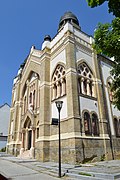
- Nitra with Nitra Castle and Saint Emmeram's Cathedral, Nitra Synagogue, Dražovce church, etc.
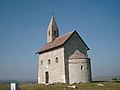
- Medieval churches in Kostoľany pod Tribečom and Nitrianska Blatnica
- Chateau and European bison sanctuary in Topoľčianky (Topoľčianska zubria zvernica)
- Šaľa - town with a castle
- The water mill and bridge in Kolárovo
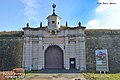
- Komárno with its fortification system, fortress, Elisabeth bridge, etc.
- Iža - Roman military camp Celemantia - UNESCO World Heritage Site
- Štúrovo - Bridge of Mária Valéria
- Levice with Levice Castle, Saint Michael's Church, Levice Town Hall etc.
- Arboretum in Tesárske Mlyňany
- Dunajské luhy Protected Landscape Area
- Ponitrie Protected Landscape Area
Remove ads
Photo gallery
 Topoľčany Castle
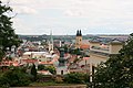


 Nitrianska Blatnica church
 Kostoľany pod Tribečom church
 Topoľčianky chateau
 European bison in Topoľčianska zubria zvernica
 Šaľa castle
 Water mill in Kolárovo


 Levice Castle, Levice
 Levice Town Hall, Levice
 Church of Saint Michael, Levice
 Arboretum Tesárske Mlyňany


_02.jpg)


.jpg)


Remove ads
See also
- Nyitra County of the Kingdom of Hungary
References
External links
Wikiwand - on
Seamless Wikipedia browsing. On steroids.
Remove ads