Top Qs
Timeline
Chat
Perspective
Noorderhaaks
Island in the Netherlands From Wikipedia, the free encyclopedia

Remove ads
Noorderhaaks (Dutch pronunciation: [ˌnoːrdərˈɦaːks]), also called Razende Bol (Raging sandbank in Dutch; in modern Dutch Bol means sphere, but in this context the old Dutch meaning of sandbank is meant[1]), is an uninhabited Dutch islet[2] in the North Sea, a few kilometres west of the Marsdiep which separates the island of Texel from the mainland of the Netherlands. The island covers an area of around 5 km2 (1.9 sq mi), although the exact area varies due to tide and the dynamic nature of the area.

Being relatively untouched by man, the island has become a valuable location due to its presence of several kinds of seabirds, and seals.
The island is slowly moving eastward towards the Marsdiep and the Molengat, at a pace of around 100 metres a year.[2] Noorderhaaks is probably the sixth sand bar to develop in the mouth of the Marsdiep, since it formed in the late twelfth century via a flood that occurred in 1170. The previous five have also moved towards Texel and got accreted to the island, with intervals of approximately 150 years each.[3]
The island is visited by day trippers, and is also being used as a training ground for the Royal Netherlands Navy and Air Force.
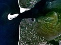 Satellite photo, taken circa 1992
 Stranded humpback whale (2012)
 Time-lapse (1984-2017)

.jpg)

Remove ads
References
External links
Wikiwand - on
Seamless Wikipedia browsing. On steroids.
Remove ads