Top Qs
Timeline
Chat
Perspective
Nusa Penida
Island in Indonesia From Wikipedia, the free encyclopedia

Remove ads
Nusa Penida (Indonesian pronunciation: [nuˈsa pəˈnida]; Balinese: ᬦᬸᬲᬧᭂᬦᬶᬤ, romanized: nusa pĕnida) is an island located near the southeastern Indonesian island of Bali, which forms a district of the same name in Klungkung Regency. The Badung Strait separates the island and Bali. The interior of Nusa Penida is hilly with a maximum altitude of 524 metres, and the climate is drier than Bali. Like Bali, it is a major tourist destination.


_of_Nusa_Penida,_Bali_(2025)_-_img_11.jpg)


In addition to Nusa Penida, the administrative district of Nusa Penida includes the nearby islands of Nusa Lembongan and Nusa Ceningan, plus eleven even smaller islands. The district had a population of 45,110 at the 2010 census, covering 202.84 km2 (78.32 sq mi),[2] and the official estimate as of 2024 was 65,820.[1]

Remove ads
History
Summarize
Perspective

The history of the island of Nusa Penida in Bali began in the 10th century. The earliest writings about Nusa Penida have indeed been found on the Belanjong pillar, which dates back to 914 AD. This pillar contains an inscription that mentions the military expedition of the first Balinese King, Sri Kesari Warmadewa, to conquer Nusa Penida.[3]
The people of Nusa Penida have long been able to fight against Balinese kings who have organized many other military expeditions. However, in the second half of the 17th century, the island of Nusa Penida was definitely conquered by the Gelgel Dynasty expedition. The last king of Nusa Penida, Dalem Bungkut, was killed in battle. Nusa Penida then became part of the Klungkung palace, one of the nine kingdoms in Bali. After the integration of Bali into the Dutch East Indies in 1908 which later became Indonesia later, Nusa Penida remained attached to Klungkung Regency.[3]
A Dutch map made in 1900 refers to Nusa Penida as Bandit Island because the Klungkung Kingdom once deported criminals, political opponents and black magic experts to Nusa Penida.[3][4]
Remove ads
Geography

Administratively, this district in Klungkung Regency consists of 4 districts (Klungkung District, Banjarangkan District, Dawan District and Nusa Penida District). Nusa Penida District consists of three islands, namely Nusa Penida Island, Lembongan Island and Ceningan Island, and consists of 16 Village Offices. Nusa Penida Island can be reached from four dock locations.[5]
Remove ads
Languages
The people of Nusa Penida speak a unique dialect of Balinese called Nusa Penida Balinese (basa Nosa), which cannot be understood by speakers from mainland Bali. It is reportedly close to the language of the Bali Aga, Bali's aboriginal population.[6]
Conservation
Summarize
Perspective
Bali Bird Sanctuary

Nusa Penida, together with neighbouring Lembongan and Ceningan Islands, forms a bird sanctuary.[7] The island communities have used traditional Balinese village regulations to create the sanctuary. The idea of a sanctuary came from the Friends of the National Parks Foundation (FNPF).[8]
In 2006 all 35 villages (now 41 villages) agreed to make bird protection part of their traditional regulations (Balinese: ᬳᬯᬶᬕ᭄ᬳᬯᬶᬕ᭄, romanized: awig-awig). Since then, the FNPF has rehabilitated and released various Indonesian birds, most notably the critically endangered Bali starling/Bali myna which is endemic to Bali but whose numbers in the wild had declined to less than 10 in 2005. After a two-year program by FNPF in which 64 cage-bred birds were rehabilitated and released onto Nusa Penida, their number had increased to over 100 in 2009. Isolated from the mainland of Bali, Nusa Penida and its neighboring island of Nusa Ceningan have advantages compared to their natural habitat on the island of Bali. From the results of the evaluation of vegetation and abundance of food on this karst island, Nusa Penida is quite abundant with various types of fruits, insects and various foods that are suitable for the living space of the Bali starling.[9]
Other


Remove ads
Tourism
Summarize
Perspective
Destinations
Points of interest on Nusa Penida include:
- Kelingking Beach

Kelingking Beach - Broken Beach
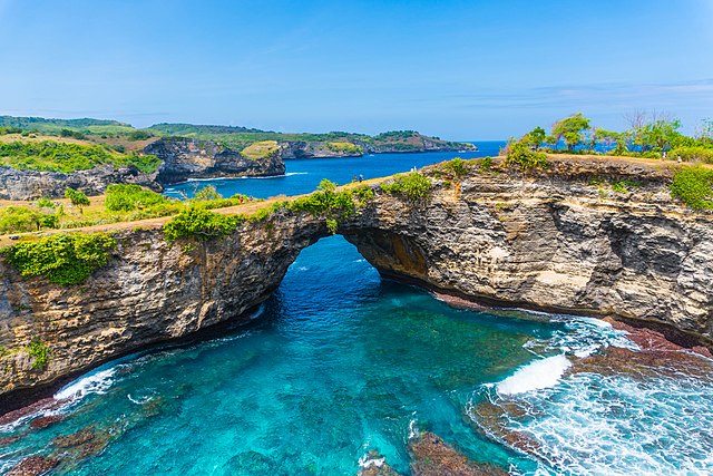
Broken Beach, Nusa Penida - Angel Billabong
- Crystal Bay
- Atuh Beach
- Diamond Beach

Diamond Beach - Suwehan Beach
- Peguyangan Waterfall
- Tembeling Forest
- Segening Waterfall
.jpg)

Dive sites
Nusa Penida covers a wide area of diving locations, including Penida Bay, Batu Lumbung (Manta Point), Batu Meling, Batu Abah, Toya Pakeh, and Malibu Point.[10] The flow through the Lombok Strait is, overall, south-tending, although the strength and direction of the tidal streams are influenced by the monsoon seasons.
During the southeast monsoons, the tidal flow tends south; during the northeast monsoons, the tidal flow tends north. In the area of the strait north of Nusa Penida, the pattern is relatively simple, with a flow, at peak tide, of about three-and-one-half knots. Tidal streams in Badung Strait are semi-diurnal, but the character of the stream is very complicated because its direction runs obliquely to the general south-to-north direction of Lombok Strait, and the channel has a curved shape.
Based on a survey in 2009, there were about 1,419 hectares of coral sites with 66 percent covering the sites in 3 metres depth and 74 percent covered the sites in 10 metres depth.[11]
In December 2024, a colony of Galaxea astreata, one of the largest coral colonies in the world, was discovered, covering an area of approximately 4000 m2 with dimensions 34 m (width), 32 m (length) and 5.5 m (height).[12]
Remove ads
In popular culture
- Noesa Penida, a 1941 film by Andjar Asmara
See also
References
External links
Wikiwand - on
Seamless Wikipedia browsing. On steroids.
Remove ads