Top Qs
Timeline
Chat
Perspective
Nusa Ceningan
Island in Indonesia From Wikipedia, the free encyclopedia
Remove ads
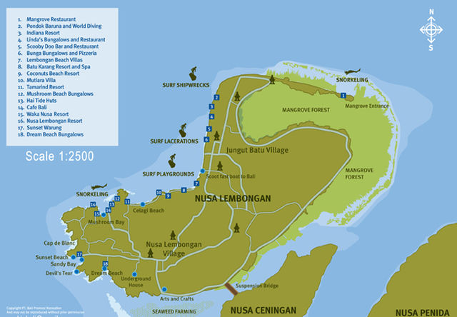
Nusa Ceningan (Balinese: ᬦᬸᬲᬘᭂᬦᬶᬗᬦ᭄; pronounced [ˌnusa t͡ʃəˈniŋan]) is a small island located in Nusa Penida District, Klungkung Regency, Bali, Indonesia; between Nusa Lembongan to the north-west and Nusa Penida to the south-east and south-east. All three islands are south-east of mainland Bali and lie on the southern side of the Strait of Badung. As none of the three islands have an airport, a boat or ferry is required to get to Nusa Ceningan.

There is a notable surf break off Nusa Ceningan which attracts some surfers away from the more crowded breaks on Nusa Lembongan.
The island offers some scenic roads and paths, and the westward views back over Nusa Lembongan to Bali are impressive. Viewing the sunset over Bali from the central Ceningan ridge is very much worth the effort. The estuarine channel between Lembongan and Ceningan is home to many seaweed farms and pristine mangrove forests.[1]
Remove ads
Administration
Administratively, Nusa Ceningan is a part of the territory of Lembongan Village in the Nusa Penida District of Klungkung Regency located in the southeast of Bali Province in Indonesia. It is consists of 2 hamlets (now administrative hamlets), namely Ceningan Kawan hamlet and Ceningan Kangin hamlet, with a population of 1,523 people, spread across 6 customary hamlets, namely Parangan Tengah, Ambentiying, Ceningan Tengah, Anggrek , Batumelawang and Gili Mekarnadi customary hamlets.[1]
Remove ads
Geography
The island is 3.9 km long and 1.1 km wide, with an area of 3 square kilometers. It is located 15 km from Bali and 1 km from Nusa Penida. It is accessible by boat from Sanur or by the suspension bridge connecting it to Nusa Lembongan, which is only accessible by pedestrians and two-wheelers. The shallow channel separating the two small islands is difficult to navigate at low tide.
To the east, the Lombok Strait separates the three islands from Lombok and marks the biogeographic division between the fauna of the Indomalayan and Australasian. The transition is known as the Wallace Line, after Alfred Russel Wallace, who was the first to propose a transition between these two major biomes.
Remove ads
Activities
The island is a nesting area for birds. It contains caves and is home to the historic pura (temple), the existence of holy places (pura) of Nusa Ceningan based on its layout and function can be detailed as follows: At the easternmost end there is Pura Batu Banglas/Goa Raja, in the north Pura Bakung, South Pura Tirta Dalem Buhu, in the west Pura Batumelawang and in the middle is Pura Tri Adi Sakti, and there are still Pura Ceng Mundi Raja Peni, Pura Wayah Dalem Majapahit, Pura Pesamuan Lawang Sari and Pura Payogan Manik Gumulung all of these temples have their own history and stories when associated with the existence and history of Ceningan Island and Nusa Penida. In addition to being a spiritual place because Nusa Ceningan is believed to be a holy land, there are also tourist attractions scattered throughout Ceningan such as swallow's nests and good waves for surfing located in the southeast of Bali Island. The waves are popular for surfing.
95% of the population lives off seaweed farming.
Connection to Nusa Lembongan


It is connected to Nusa Lembongan Island through a narrow suspension bridge who collapsed in 2016 and rebuilt.[2][3]
Tourism
Nusa Ceningan has been slowly growing in popularity since 2009.
A key tourist attraction is the Mahana cliff jump, which is located on the southeastern side of Nusa Ceningan at Mahana Point Bar. The bar manages two diving platforms at 5 and 13 meters. Jumping is only permitted when the tide is high enough.
See also
References
Wikiwand - on
Seamless Wikipedia browsing. On steroids.
Remove ads


