Top Qs
Timeline
Chat
Perspective
Ongkharak district
District in Nakhon Nayok, Thailand From Wikipedia, the free encyclopedia
Remove ads
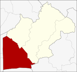
Ongkharak (Thai: องครักษ์, pronounced [ʔōŋ.kʰā.rák]) is a district (amphoe) in the western part of Nakhon Nayok province, central Thailand.
Once King Chulalongkorn (Rama V) visited Mueang Nakhon Nayok. When he and his company arrived in the area of Ongkharak District, one of the royal guard fell ill and died. The king ordered a shrine built to commemorate his servant. Ongkharak means 'royal guard'.[2]
Remove ads
History
The old district office of Ongkharak was in Tambon Bang O (now in Ban Na district). In 1889 King Chulalongkorn ordered the construction of the Rangsit Canal, a canal that links the Chao Phraya and Nakhon Nayok Rivers. The water gate in the Chao Phraya River was named Chulalongkorn Water Gate (ประตูน้ำจุฬาลงกรณ์), and its corresponding gate in the Nakhon Nayok River was named Saovabha Bhongsi Water Gate (ประตูน้ำเสาวภาผ่องศรี). The district office was moved near the 16th Khlong of Khlong Rangsit. Twenty years later, the office moved to a place next to the Saovabha Bhongsi Water Gate. Now the district office is behind Saovabha Market, 500 m from the old office.[2]
Originally, Ongkharak district was divided into seven subdistricts (tambons). In 1968, Pho Thaen (no.4) was separated from Bang Pla Kot (no.7).[3] In 1969, Bang Sombun (no.5) was separated from Bang Luk Suea (no.8).[4] In 1984, Chumphon (no.10) was separated from Bueng San (no.2).[5] In 1990, Khlong Yai (no.11) was separated from Ongkharak (no.9).[6]
Remove ads
Geography
Neighboring districts are (from the northeast clockwise): Ban Na and Mueang Nakhon Nayok of Nakhon Nayok Province; Ban Sang of Prachinburi province; Bang Nam Priao of Chachoengsao province; Lam Luk Ka, Thanyaburi, and Nong Suea of Pathum Thani province.
The important water resources are the Nakhon Nayok River and Khlong Rangsit.
Religion
There are thirty-three Theravada Buddhist temples in the district.
One in Bueng San, Chumphon, Khlong Yai, Pho Thaen and Phra Achan, three in Ongkharak and Sai Mun, five in Bang Luk Suae and Bang Pla Kot, six in Bang Sombun and Sisa Krabue.[7]
In Phra Achan and Chumphon subdistricts have Muslims their eleven mosques.
Administration
Summarize
Perspective
Central government
The district is divided into eleven subdistricts (tambons), which are further subdivided into 116 villages (mubans).[1]

Local government
As of December 2023 there is : Ongkharak subd. municipality (thesaban tambon) and covers parts of Ongkharak and Sai Mun subdistricts. There are further eleven subdistricts administrative organizations - SAO (ongkan borihan suan tambon - o bo toh).[1]
| Ongkharak subd. municipality | Pop. | website |
| Ongkharak | 2,160 | ongkarak |
| Sai Mun | 405 | |
| Total | 2,565 |
Remove ads
Education
Higher education
- Srinakharinwirot University's, Ongkharak campus is in the district.
- St.Theresa International University.[8]
Primary/secondary education
There are 36 primary and 2 secondary schools in the district.
Healthcare
Government hospitals
There are two hospitals in Ongkharak district.
- Ongkharak hospital with 31 beds.
- HRH Princess Maha Chakri Sirindhorn Medical Center with 500 beds is the teaching hospital of the Faculty of Medicine of Srinakharinwirot University.
Health-promoting hospitals
There are total 15 health-promoting hospitals in the districts, of which; one in Bueng San, Pho Thaen, Bang Pla Kot, Bang Luk Suea and Chumphon and two in Phra Achan, Sisa Krabue, Bang Sombun, Sai Mun and Khlong Yai.[9]
Remove ads
References
Wikiwand - on
Seamless Wikipedia browsing. On steroids.
Remove ads


