Top Qs
Timeline
Chat
Perspective
Otter Trail
Hiking trail along the Garden Route coast, South Africa From Wikipedia, the free encyclopedia

Remove ads
The Otter Trail is a hiking trail along the Garden Route coast of South Africa and is named for the Cape clawless otter[1] which occurs in this region. This trail is widely regarded as one of the finest in the world and stretches from Storms River Mouth in the east to Nature's Valley in the west, is 26 km long as the crow flies and 44 km as the hiker walks. Walking the trail takes 5 days, and the 4 nights are spent in comfortable huts with superb views. The route is located entirely within the Tsitsikamma National Park, which protects an 80 km long strip of coastal mountains, forest and beaches.

Otter Trail | ||||||||||||||||||||||||||||||||||||||||||||||||||||||||||||||||||||||||||||||||||||||||||||||||||||||||||||||||||||||||||||||||||||||||||||||||||||||||||||||||||||||||
|---|---|---|---|---|---|---|---|---|---|---|---|---|---|---|---|---|---|---|---|---|---|---|---|---|---|---|---|---|---|---|---|---|---|---|---|---|---|---|---|---|---|---|---|---|---|---|---|---|---|---|---|---|---|---|---|---|---|---|---|---|---|---|---|---|---|---|---|---|---|---|---|---|---|---|---|---|---|---|---|---|---|---|---|---|---|---|---|---|---|---|---|---|---|---|---|---|---|---|---|---|---|---|---|---|---|---|---|---|---|---|---|---|---|---|---|---|---|---|---|---|---|---|---|---|---|---|---|---|---|---|---|---|---|---|---|---|---|---|---|---|---|---|---|---|---|---|---|---|---|---|---|---|---|---|---|---|---|---|---|---|---|---|---|---|---|---|---|---|
| ||||||||||||||||||||||||||||||||||||||||||||||||||||||||||||||||||||||||||||||||||||||||||||||||||||||||||||||||||||||||||||||||||||||||||||||||||||||||||||||||||||||||
The trail traverses a very scenic landscape, never straying far from the shoreline, but often climbing steeply and then descending to the beach or a river crossing. Vegetation along the way is either fynbos, dense gallery forest or open, rocky sections near the sea with an abundance of wildflowers.
Remove ads
Trail landmarks
- Storms River Mouth 34°01′15.6″S 23°52′48″E
- Ngubu huts 34°01′2.9″S 23°50′31.2″E
- Oakhurst huts 33°59′42.7″S 23°44′2.5″E
- Scott hut 34°00′22.4″S 23°47′10.1″E
- André huts 33°58′45″S 23°37′5.3″E
- Grootrivier, Nature's Valley 33°58′56″S 23°34′36″E
Trail stages
- Day 1 - 4.8 km (± 2 hours) Storms River Mouth - Ngubu
- Day 2 - 7.9 km (± 4 hours) Ngubu - Scott
- Day 3 - 7.7 km (± 4 hours) Scott - Oakhurst
- Day 4 - 13.8 km (± 6 hours) Oakhurst - André
- Day 5 - 9.8 km (previously 6.8 km) (± 3 hours) Vasselot - Nature's Valley
- Total distance 44 km
Elevation distances - vertical climb and descent
- Day 1 - 561 m total vertical - Climb 188 m - Descent -373 m
- Day 2 - 1480 m total vertical - Climb 746 m - Descent -734 m
- Day 3 - 1257 m total vertical - Climb 623 m - Descent -634 m
- Day 4 - 1905 m total vertical - Climb 945 m - Descent -960 m
- Day 5 - 926 m total vertical - Climb 466 m - Descent -460 m
- Total elevation gain: 2 968m
Gallery
 Tidal pools at Ngubu huts
 Oakhurst huts at Lottering estuary
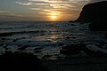 Sunset at André huts, Kliprivier
 Bloukrans river mouth


See also
References
External links
Wikiwand - on
Seamless Wikipedia browsing. On steroids.
Remove ads