Top Qs
Timeline
Chat
Perspective
Palashpai
Village in West Bengal, India From Wikipedia, the free encyclopedia
Remove ads
Palashpai is a village in the Daspur II CD block in the Ghatal subdivision of the Paschim Medinipur district in the state of West Bengal, India.


Remove ads
Geography
Summarize
Perspective

8km
5miles
5miles
[
Rupnarayan River
H
Uttar Bar
H
Radhanagar
H
Radhakantapur
H
Palashpai
H
Narajole
H
Laoda
H
Lachhipur
H
Kotalpur
H
Jayantipur
H
Jalshara
H
Iswarpur
H
Gobindanagar
H
Gangadaspur
H
Dihi Baliharpur
H
Chaipat
H
Baikunthapur
H
Alui
H
Ajuria
R
Birsingha
R
Sonakhali
R
Daspur
M
Ramjibanpur
M
Khirpai
M
Kharar
M
Ghatal
M
Chandrakona
Cities and towns in Ghatal subdivision of Paschim Medinipur district
M: municipal city/ town, R: rural/ urban centre, H: historical/ religious centre
Owing to space constraints in the small map, the actual locations in a larger map may vary slightly
M: municipal city/ town, R: rural/ urban centre, H: historical/ religious centre
Owing to space constraints in the small map, the actual locations in a larger map may vary slightly
Location
Palashpai is located at 22.5194°N 87.7884°E.
Area overview
Ishwar Chandra Vidyasagar, scholar, social reformer and a key figure of the Bengal Renaissance, was born at Birsingha on 26 September 1820.[1][2]
Ghatal subdivision, shown in the map alongside, has alluvial soils. Around 85% of the total cultivated area is cropped more than once.[3] It has a density of population of 1,099 per km2, but being a small subdivision only a little over a fifth of the people in the district reside in this subdivision. 14.33% of the population lives in urban areas and 86.67% lives in the rural areas.[4]
Note: The map alongside presents some of the notable locations in the subdivision. All places marked in the map are linked in the larger full screen map.
Remove ads
Demographics
According to the 2011 Census of India, Palashpai had a total population of 4,800, of which 2,459 (51%) were males and 2,341 (49%) were females. There were 480 persons in the age range of 0–6 years. The total number of literate persons in Palashpai was 3,864 (89.44% of the population over 6 years).[5]
Education
Palashpai B.D. Balika Vidyalaya is a Bengali-medium girls only institution established in 1965. It has facilities for teaching from class V to class X. It has a library with 350 books and a playground.[6]
Bhagwanchak Patiram Sikshaniketan is a Bengali-medium coeducational institution established in 1950. It has facilities for teaching from class V to class XII. It has a library with 1,200 books and a playground.[7]
Palashpai picture gallery
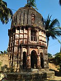 Saptarath Sridharjiu deul of the Maity family constructed in 1834
 Temple entrance
 Terracotta decoration


References
External links
Wikiwand - on
Seamless Wikipedia browsing. On steroids.
Remove ads