Top Qs
Timeline
Chat
Perspective
Palpara
Neighbourhood in Nadia, West Bengal, India From Wikipedia, the free encyclopedia
Remove ads
Palpara is a neighbourhood in Chakdaha, in Kalyani subdivision of the Nadia district in the state of West Bengal, India. The Palpara railway station is 59 km from Sealdah railway station, and 51.4 km from Krishnanagar railway station. Palpara is famous for its 17th-century terracotta Kali temple, also popularly known as "Palpara Temple", which is now under the supervision of Archaeological Survey of India (ASI).[1]


Remove ads
Geography

8km
5miles
5miles
W
Hooghly
River
River
F
AIIMS Kalyani
F
University of Kalyani
R
Palpara
R
Mohanpur
R
Chaugacha
M
Haringhata
M
Gayespur
M
Chakdaha
M
Kalyani
CT
Digha
CT
Subarnapur
CT
Simhat
CT
Kulia
CT
Saguna
CT
Madanpur
CT
Jangal
CT
Priyanagar
CT
Shimurali
CT
Chanduria
CT
Lalpur
CT
Darappur
CT
Punglia
Cities and towns in Kalyani subdivision of Nadia district
M: municipal town/city/notified area, CT: census town, R: rural/urban centre.
Owing to space constraints in the small map, the actual locations in a larger map may vary slightly.
M: municipal town/city/notified area, CT: census town, R: rural/urban centre.
Owing to space constraints in the small map, the actual locations in a larger map may vary slightly.
Location
Palpara is located at approximately 23.060°N 88.521°E.
Note: The map alongside presents some of the notable locations in the subdivision. All places marked in the map are linked in the larger full screen map. All the four subdivisions are presented with maps on the same scale – the size of the maps vary as per the area of the subdivision.
Remove ads
Education
There are two high schools in Palpara. One secondary school, named Palpara Vidyamandir, and one higher secondary school, named Bhawanipur Sukanta Vidyaniketan.[2] There is a law college near Palpara, named J.R.S.E.T. College of Law.
Culture
Durga Puja, Kali Puja and Saraswati Puja are widely celebrated. Multiple fairs are held in the nearby club grounds of "Chhatramilani" and "Bibadi Club".
 A Durga Puja pandal in Palpara
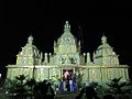 A Durga Puja pandal in Palpara


David J. McCutchion mentioned the Palpara Temple (26’ x 21’) as possibly a 17th-century structure. The ASI has built the roof to a point.[3]
Palpara Temple gallery
 Picture taken in 2013
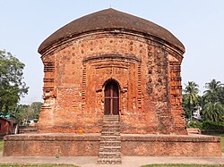 Picture taken in 2016
 Front door decoration
 Front arch panel
 Picture taken in 2018
 Terracotta lotus medallion
 ASI description


References
External links
Wikiwand - on
Seamless Wikipedia browsing. On steroids.
Remove ads