Top Qs
Timeline
Chat
Perspective
Pangutaran
Municipality in Sulu, Philippines From Wikipedia, the free encyclopedia
Remove ads
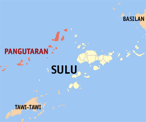
Pangutaran, officially the Municipality of Pangutaran (Tausūg: Kawman sin Pangutaran; Pangutaran Sama: Lahat Pangutaran; Filipino: Bayan ng Pangutaran), is a municipality in the province of Sulu, Philippines. According to the 2020 census, it has a population of 36,374 people.[5]
Remove ads
Geography
Barangays
Pangutaran is politically subdivided into 16 barangays. Each barangay consists of puroks while some have sitios.
- Alu Bunah
- Bangkilay
- Kawitan
- Kehi Niog
- Lantong Babag
- Lumah Dapdap
- Pandan Niog
- Panducan
- Panitikan
- Patutol
- Se-ipang
- Simbahan (Poblacion)
- Suang Bunah
- Tonggasang
- Tubig Nonok
- Tubig Sallang
Climate
Remove ads
Demographics
Remove ads
Economy
Poverty Incidence of Pangutaran
10
20
30
40
50
60
70
80
2000
71.47 2003
61.30 2006
50.90 2009
49.28 2012
51.85 2015
48.34 2018
76.75 2021
62.35 Source: Philippine Statistics Authority[12][13][14][15][16][17][18][19] |
Etymology
The name PANGUTARAN is originally after the "Shariff Pangutaran" name, the first Filipino people who discover and inhabited the island together with the family members (Belong to Salip Descendants). But before what we know today as PANGUTARAN it is also called "Pulau Bangkuruan" by Malay speakers means The island with the Bangkudo tree(s) (Morinda citrifolia). The word phrase "Siyama" stands un impossible originated from the Hindi language meaning "Forbearance" or "kshama:क्षमा" because sheikh Karim Al-Makhdum arrived (in Bohe' Indangan, Simunul, Tawi-Tawi, Philippines in 1380 and propagated Islam) in the Philippines contemporary with Hindi traders from India.
Remove ads
References
External links
Wikiwand - on
Seamless Wikipedia browsing. On steroids.
Remove ads


