Top Qs
Timeline
Chat
Perspective
Perama
Municipality in Greece From Wikipedia, the free encyclopedia
Remove ads
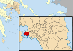
Perama (Greek: Πέραμα) is a coastal town and a suburb of Piraeus and belongs to the Piraeus regional unit and is the southwestern limit of Athens urban area.[3][4] It lies on the southwest edge of the Aegaleo mountains, on the Saronic Gulf coast. It is 8 km northwest of Piraeus, and 14 km west of the center of Athens. The municipality has an area of 14.729 km2.[5] It forms the western terminus of the Port of Piraeus, and there is also a passenger port that provides ferry services to Salamis Island.[6]
The name Perama comes from the Greek word "perasma" which means "passage". Perama has a secondary soccer team named Peramaikos. The Battle of Salamis which took place in 480BC was located between the Salamis island and the mainland, part of which included Perama.
Remove ads
Historical population
Climate
Summarize
Perspective
According to the station of the National Observatory of Athens Perama has a hot semi-arid climate (Köppen climate classification: BSh) with mild winters and hot summers.
Remove ads
See also
References
External links
Wikiwand - on
Seamless Wikipedia browsing. On steroids.
Remove ads


