Top Qs
Timeline
Chat
Perspective
Petaling District
District of Selangor in Malaysia From Wikipedia, the free encyclopedia
Remove ads
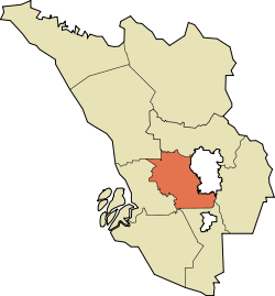
The Petaling District is a district located in the heart of Selangor in Malaysia. Petaling is not to be confused with the city of Petaling Jaya located in it, nor the mukim of Petaling under Subang Jaya City. The district office is located in Subang.
The district of Petaling was established on 1 February 1974, the same day Kuala Lumpur was declared a Federal Territory. This district is located in the middle of the Klang Valley adjacent to the capital and thus has experienced tremendous urbanisation. Some of the original forests remain in the Bukit Cherakah Forest Reserve (including the National Botanic Gardens), Kota Damansara Community Forest Park and Bukit Gasing. During the 1991 census, it recorded 633,165 people.[citation needed]
The official 2010 census recorded the population of Petaling as 1,660,869 people, excluding foreigners.[4] Petaling is 484.32 km2 in area.[3] The urban centres are divided into the cities of Shah Alam, Petaling Jaya and Subang Jaya. However, there are numerous town subdivisions, old subdistrict administrations (mukim), all of which share the same names like Damansara, Subang, and Petaling, which add much to the administrative confusion along with the rapid growth. Some five types of subdivisions exist for Petaling District, namely the re-organized municipal council majlis, the majlis subdivisions, the community names (also known as townships), electoral constituencies, and the subdivisions ("mukim").
It is host to many thriving townships such as the Damansara area, which hosts several shopping malls including a Tesco and an IKEA outlet. Sultan Abdul Aziz Shah Airport is situated in Subang.
Remove ads
Population
The following is based on Department of Statistics Malaysia 2010 census.[4]
Remove ads
Administrative divisions
Summarize
Perspective

Petaling District is divided into 4 mukims. It was formed in 1974 by incorporating mukim Bukit Raja and Damansara (Klang District) with mukim Sungai Buloh and Petaling which was part of Kuala Lumpur district. However, this definition is for historic administrative purposes only and does not reflect the modern rapid growth and subsequent reorganisation in 1997.
|
 |
Government


The district is highly urbanised, and as such, the administration and maintenance of the public facilities in the district have been divided and delegated to the three local governments.
Shah Alam City Council
The Shah Alam City Council (MBSA) governs the city centre of Shah Alam. It also exercises jurisdiction over some parts of the south of Klang District, Bukit Raja, Setia Alam, Subang and Sungai Buloh area.
Petaling Jaya City Council
The city council (MBPJ) administers the area of the city of Petaling Jaya which includes Damansara (Petaling Jaya Utara, PJU), Petaling Jaya centre and most of Petaling Jaya Selatan (PJS) except PJS7/PJS9/PJS11 (commonly known as Bandar Sunway) which is partially jurisdictional and postcode allocated for location purposes, and SS12-SS19 which previously administrates under MBPJ previous incarnation Petaling Jaya Municipal Council (MPPJ), transferred the administration power to Subang Jaya Municipal Council (MPSJ) on 1997, the same year MPSJ was upgraded from Petaling District Council.[citation needed]
Subang Jaya City Council
The city council governs the southern parts of the district with the main populated areas such as Subang Jaya, UEP Subang Jaya (USJ), Putra Heights, Batu Tiga, parts of Puchong and Seri Kembangan under its jurisdiction.
Remove ads
Federal Parliament and State Assembly Seats

List of Petaling district representatives in the Federal Parliament (Dewan Rakyat)
List of Petaling district representatives in the State Legislative Assembly (Dewan Undangan Negeri)
Remove ads
See also
Wikimedia Commons has media related to Petaling District.
References
Wikiwand - on
Seamless Wikipedia browsing. On steroids.
Remove ads


