Top Qs
Timeline
Chat
Perspective
Peter Martyr map
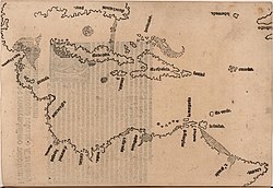
Spanish map of the Caribbean, 1511 or 1514 From Wikipedia, the free encyclopedia
Remove ads
The Peter Martyr map is a Spanish woodcut map composed in 1511 or 1514 and included in most or some copies of the 1511 edition of Decades of the New World by Peter Martyr d'Anghiera. The map depicts the insular and continental Caribbean coastlines and soundings as understood in the early 1510s by Iberian authorities. It is deemed the first print map of the Caribbean, and possibly the first such to focus specifically on the New World.
Remove ads
History
Summarize
Perspective
Details of the map's provenance remain unclear, though a good few theories have been proposed.[3][n 2] Traditionally, it has been dated to 1511 and attributed to Martyr, in keeping with the provenance of the first edition of Decades of the New World.[4][n 3] Recently, however, the University of Valladolid-affiliated scholar, Jesús Varela Marcos, has proposed that the map was created jointly by Martyr and Juan Rodríguez de Fonseca in 1514, and thereafter included a posteriori in copies of the former's 1511 edition of Decades.[5] Varela Marcos argues that the map's noticeable distortion is political in nature, and proffers Fonseca as the most likely candidate for said influence.[6][n 4] Furthermore, they argue, (i) the map depicts post-1511 discoveries, (ii) some exemplars of the 1511 Decades have no map, and (iii) at least some exemplars with the map have had it inserted at a later date.[7][n 5] The Varela Marcos provenance has been accepted in some, but not all, recent literature.[n 6]
Curiously, Varela Marcos claims the following Decades passage, describing a map-making session by Martyr and Fonseca, in fact describes a 4 December 1514 session in which the very Peter Martyr map was composed.[10]
[W]e examined numerous reports of those expeditions, and we have likewise studied the terrestrial globe on which the discoveries are indicated, and also many parchments, called by the explorers navigators' charts. [...] When all these maps were spread out before us, and upon each a scale was marked in the Spanish fashion, [...] we set to work to measure the coasts with a compass, [...].
— Martyr in Decades.[n 7]
Remove ads
Content
Summarize
Perspective
The map makes note of maritime hazards, such as banks and reefs, and further outlines known insular and continental coasts, listing some placenames near these, but lacks elementary cartographic elements, such as lines of longitude and latitude, and is noticeably distorted.[11] The distortion is particularly along the y-axis.[12] For instance, Gibraltar, Bermuda, and Isla de beimeni are depicted on roughly the same latitude, despite actually being at 37º, 32º, and 25º (assuming Florida as beimeni) north, respectively. Similarly, the Canary Islands, Hispaniola, and Puerto Rico are depicted at roughly the same parallel, despite being at 28º, 18º, 17º north, respectively.[13]
Toponyms
Remove ads
Analysis
Summarize
Perspective
Sources
Martyr, in virtue of his 'privileged position' within the court of the Catholic Monarchs, is thought to have been privy to current discoveries of the day, and to classified intelligence therefrom, via, for instance, personal debriefings from leading explorers.[14] Varela Marcos has recently claimed the following Decades passage, listing sources employed during a map-making session by Martyr and Fonseca, in fact names the very sources of the Peter Martyr map.[15]
[W]e examined numerous reports of those expeditions, and we have likewise studied the terrestrial globe on which the discoveries are indicated, and also many parchments, called by the explorers navigators' charts. One of these maps had been drawn by the Portuguese, and it is claimed that Amerigo Vespucci of Florence assisted in its composition. [...] Columbus, during his lifetime, began another map while exploring these regions, and his brother, Bartholomew Columbus, Adelantado of Hispaniola, who has also sailed along these coasts, [added what he saw fit to it]. From thenceforth, every Spaniard who thought he understood the science of computing measurements, has drawn his own map; the most valuable of these maps are those made by the famous Juan de la Cosa, companion of Hojeda, [... and] Andrés Morales [...].
— Martyr in Decades.[n 9]
Content

Commenting on the map's noticeable distortion, Jesús Varela Marcos suggests Fonseca, the bishop of Burgos, may have requested or required it 'in order to highlight clearly that what was shown on the map was within the area of natural expansion of Spain.'[16] In a 2005 paper for The Florida Geographer, the unaffiliated scholar Douglas T Peck proposed a correction of the northwestern portion of the map which shifted the western continental coastline down by some six degrees.[17][n 11]
Remove ads
Legacy
Copies of the Peter Martyr map 'have long been separated from their parent document and have been reproduced extensively in studies and popular literature on early cartography.'[18]
See also
- Cantino map, ca 1502 Portuguese world map
- Caveri map, ca 1504 Genoese world map
- Waldseemüller map, ca 1507 German world map
- Egerton 2803 maps, ca 1508 or ca 1510 Italian world atlas
Notes and references
External links
Wikiwand - on
Seamless Wikipedia browsing. On steroids.
Remove ads


