Top Qs
Timeline
Chat
Perspective
Pinrang Regency
Regency in South Sulawesi, Indonesia From Wikipedia, the free encyclopedia
Remove ads
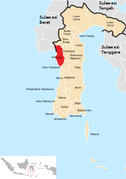
Pinrang Regency (Buginese: ᨄᨙᨋ, romanized: Pénrang) is one of the twenty-one regencies in South Sulawesi Province of Indonesia. Pinrang town in Watang Sawitto District is the administrative capital of Pinrang Regency. The regency is situated in the northwest of the South Sulawesi peninsula, and covers a land area of 1,896.57 km2. It had a population of 351,161 at the 2010 Census[2] and 403,994 at the 2020 Census;[3] the official estimate as at mid 2023 was 417,932 (comprising 206,252 males and 211,680 females).[1]
Remove ads
Administrative districts
Summarize
Perspective
Pinrang Regency comprises twelve administrative Districts (Kecamatan), tabulated below with their areas and their populations at the 2010 Census[2] and the 2020 Census,[3] together with the official estimates as at mid 2023.[4] The table also includes the location of the district administrative centres, the number of administrative villages in each district (totalling 69 rural desa and 40 urban kelurahan), and its post code.
Notes: (a) including the offshore islands of Pulau Dapo, Pulau Kamerrang and Pulau Lawakkoang. (b) Tellumpanua and Watang Suppa. (c) Langnga and Pallameang.
(d) Lanrisang kelurahan. (e) Manarang and Padaidi. (f) Bentengnge, Jaya, Macorawalie, Penrang, Salo, Sawitto, Siparappe and Sipatokkong.
(g) Benteng Sawito, Laleng Bata, Macinnae, Mamminasae, Pacongang and Temmassarangnge. (h) Fakkie, Marawi, Mattiro Deceng, Pammase, Samaturue and Tiroang.
(j) Benteng, Maccirinna, Teppo and Tonyamang. (k) Cempe kelurahan. (l) Bittoeng, Data, Lampa, Pekkabata and Tatae. (m)
Kassa kelurahan. (n) Betteng and Taddokong.
Remove ads
Climate
Pinrang has a tropical rainforest climate (Af) with moderate to heavy rainfall year-round. The following climate data is for the town of Pinrang.
Remove ads
References
External links
Wikiwand - on
Seamless Wikipedia browsing. On steroids.
Remove ads


