Top Qs
Timeline
Chat
Perspective
Pirgacha Upazila
Upazila in Rangpur, Bangladesh From Wikipedia, the free encyclopedia
Remove ads
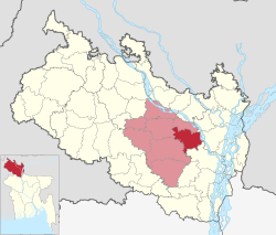
Pirgacha (Bengali: পীরগাছা) is an upazila (subdistrict) of Rangpur District in the division of Rangpur, Bangladesh.[3]
Remove ads
Geography
Pirgacha is located at 25.5806°N 89.4000°E. It has 82,623 households and total area 266.85 km2. Tambulpur on the bank of River Burail. Pirgacha upazila is at the south-east corner of Rangpur town. Tambulpur is the largest union of Pirgacha Upazila. It is about 12 kilometers east to west and about 6 kilometers north to south.
Demographics
According to the 2011 Census of Bangladesh, Pirgachha Upazila had 82,623 households and a population of 313,319. 68,918 (22.00%) were under 10 years of age. Pirgachha had a literacy rate (age 7 and over) of 44.61%, compared to the national average of 51.8%, and a sex ratio of 1041 females per 1000 males. 13,037 (4.16%) lived in urban areas.[5][6]
As of the 1991 Bangladesh census, Pirgachha has a population of 256,573. Males constitute 50.59% of the population, and females 49.41%. This Upazila's eighteen up population is 125484. Pirgachha has an average literacy rate of 21.5% (7+ years), and the national average of 32.4% literate.[7]
Remove ads
Administration
Pirgacha Upazila is divided into nine union parishad: Anandanagar, Chhaola, Itakumari, Kaikuri, Kalyani, Kandi, Parul, Pirgacha, and Tambulpur. The union parishads are subdivided into 170 mauzas and 170 villages.[5]
See also
References
Wikiwand - on
Seamless Wikipedia browsing. On steroids.
Remove ads


