Top Qs
Timeline
Chat
Perspective
Pohénégamook
City in Quebec, Canada From Wikipedia, the free encyclopedia
Remove ads
Pohénégamook (French pronunciation: [pɔeneɡamok]; pop. 2481) is a Canadian town on the Canada–United States border in Quebec's Témiscouata Regional County Municipality.
You can help expand this article with text translated from the corresponding article in French. (December 2018) Click [show] for important translation instructions.
|
The town shares the border with Estcourt Station, Maine, the northernmost point in New England.
As of 2021, Pohénégamook had 2,481 people, down 3.9% from the last census in 2016.
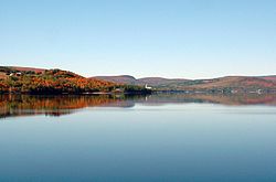
The town is named after Lake Pohenegamook and is located on the lake's southern and western shores.
Remove ads
History
Pohénégamook was amalgamated with the formerly-independent communities of Saint-Pierre d'Estcourt, Saint-Éleuthère, Village-Blier and Saint-David-de-Sully on October 23, 1973.
Demographics
In the 2021 Census of Population conducted by Statistics Canada, Pohénégamook had a population of 2,481 living in 1,171 of its 1,393 total private dwellings, a change of -3.9% from its 2016 population of 2,582. With a land area of 339.99 km2 (131.27 sq mi), it had a population density of 7.3/km2 (18.9/sq mi) in 2021.[4]
Remove ads
Attractions
Parc de la Frontière,[6] located along the southern lakeshore of Lake Pohenegamook, straddles the U.S.-Canadian border. It features a historic marker[7] and gives visitors the experience of visiting a park in two countries.
See also
- Lake Pohenegamook, a waterbody
- Boucanée River, a stream
- List of towns in Quebec
References
External links
Wikiwand - on
Seamless Wikipedia browsing. On steroids.
Remove ads


