Top Qs
Timeline
Chat
Perspective
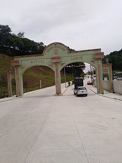
Rafael Lucio
Municipality in Veracruz, Mexico From Wikipedia, the free encyclopedia
Remove ads
Rafael Lucio is a municipality located in the montane central zone of the Mexican state of Veracruz, about 9 km from the state capital Xalapa. It has a surface of 24.68 km2. It is located at 19°35′N 96°59′W.
By Decree of November 5, 1932 Rafael Lucio's municipality and the head-board is created they are named Rafael Lucio, in honor of the illustrious doctor of Xalapa.
Remove ads
Geography
The municipality of Rafael Lucio is delimited to the north by Tlacolulan and Jilotepec, to the southeast by Banderilla, to the south by Tlalnelhuayocan and to the west by Tres Valles.[4] It is watered by small tributaries of the Actopan River.
The weather in Rafael Lucio is cold and wet all year with rains in summer and autumn.
Demographics
In 2020, Rafael Lucio recorded population of 8,343 inhabitantes in 17 localities.[5] Rafael Lucio, the municipal seat, it's the only one classified as urban, with a population of 4,837 hab. Other localities include Piletas (1,498 hab.), Teapan (725 hab.) and Tres de Mayo (258 hab.).[5]
Remove ads
Agriculture
It produces principally maize.
Celebrations
In September the celebration honoring San Miguel Archangel, patron of the town, takes place, and in December there occurs the celebration in honor of Virgin of Guadalupe.
References
External links
Wikiwand - on
Seamless Wikipedia browsing. On steroids.
Remove ads


