Top Qs
Timeline
Chat
Perspective
Razoredge Mountain
Mountain in the state of Montana From Wikipedia, the free encyclopedia

Remove ads
Razoredge Mountain (8,570 feet (2,612 m)) is located in the Lewis Range, Glacier National Park in the U.S. state of Montana.[3]


Remove ads
Geology
Like other mountains in Glacier National Park, Razoredge Mountain is composed of sedimentary rock laid down during the Precambrian to Jurassic periods. Formed in shallow seas, this sedimentary rock was initially uplifted beginning 170 million years ago when the Lewis Overthrust fault pushed an enormous slab of Precambrian rocks 3 mi (4.8 km) thick, 50 miles (80 km) wide and 160 miles (260 km) long over younger rock of the Cretaceous period.[4]
Remove ads
Climate
According to the Köppen climate classification system, Razoredge Mountain is located in an alpine subarctic climate zone with long, cold, snowy winters, and cool to warm summers.[5] Winter temperatures can drop below −10 °F with wind chill factors below −30 °F. Due to its altitude, it receives precipitation all year, as snow in winter, and as thunderstorms in summer.
Gallery
 Northeast aspect above Medicine Grizzly Lake
 Northeast aspect
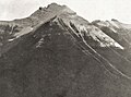 West aspect, 1914


See also
References
Wikiwand - on
Seamless Wikipedia browsing. On steroids.
Remove ads