Top Qs
Timeline
Chat
Perspective
Rearguard Mountain
Mountain in British Columbia, Canada From Wikipedia, the free encyclopedia

Remove ads
Rearguard Mountain is a 2,744-metre (9,003-foot) summit located within Mount Robson Provincial Park in British Columbia, Canada. It is part of the Rainbow Range which is a sub-range of the Canadian Rockies. Its nearest higher peak is Mount Robson, 4.0 km (2.5 mi) to the southwest.[1] Rearguard is situated between Berg Lake and the Robson Glacier.


Remove ads
History
It was named in 1922 by the Interprovincial Boundary Survey to describe the point of view of those approaching Mount Robson since the mountain is located at the rear of Robson.[4]
The mountain's name was officially adopted February 1, 1923, by the Geographical Names Board of Canada.[2] It was labelled on Arthur O. Wheeler's 1911 topographic map of Mount Robson.[5]
The first ascent was made in 1913 by an Alpine Club of Canada party.[1][4]
Remove ads
Climate
Based on the Köppen climate classification, Rearguard Mountain is located in a subarctic climate zone with cold, snowy winters, and mild summers.[6] Winter temperatures can drop below −20 °C with wind chill factors below −30 °C. The months June through September offer the most favorable weather to visit. Precipitation runoff from the mountain drains into the Robson River.
Geology
The mountain is composed of sedimentary rock laid down during the Precambrian to Jurassic periods and pushed east and over the top of younger rock during the Laramide orogeny.[7]
Gallery
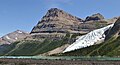 West aspect
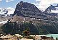 Northwest aspect
 Rearguard Mountain with Mount Robson


See also
References
External links
Wikiwand - on
Seamless Wikipedia browsing. On steroids.
Remove ads