| Regional Park |
Image |
Region |
Area km2[8][9] |
Established |
Location |
Description |
| Te Ārai Regional Park |
 |
Auckland Region |
4.77 |
2008 |
36.160°S 174.646°E / -36.160; 174.646 |
Coastal park at Te Ārai |
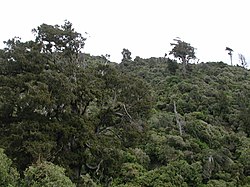
| Glenfern Sanctuary Regional Park |
 |
Auckland Region |
0.83 |
2016 |
36.163°S 175.356°E / -36.163; 175.356 |
Native forested area on Great Barrier Island |
| Pākiri Regional Park |
 |
Auckland Region |
2.51 |
1970 |
36.260°S 174.749°E / -36.260; 174.749 |
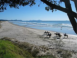
Coastal park in the northern Auckland Region and nesting area for the New Zealand fairy tern |
| Ātiu Creek Regional Park |
 |
Auckland Region |
8.43 |
2008 |
36.330°S 174.364°E / -36.330; 174.364 |
A working sheep and cattle farm on the eastern shores of the Kaipara Harbour, near Wellsford |
| Tāwharanui Regional Park |
 |
Auckland Region |
5.88 |
1973 |
36.372°S 174.827°E / -36.372; 174.827 |
Coastal farmland at the end of the Tāwharanui Peninsula, which includes the fenced Tāwharanui Open Sanctuary |
| Scandrett Regional Park |
 |
Auckland Region |
0.48 |
2004 |
36.443°S 174.774°E / -36.443; 174.774 |
Coastal park near Warkworth |
| Te Rau Pūriri Regional Park |
 |
Auckland Region |
3.49 |
2005 |
36.487°S 174.264°E / -36.487; 174.264 |
Regenerating forest and farmland park on Te Korowai-o-Te-Tonga Peninsula. |
| Mahurangi East Regional Park |
 |
Auckland Region |
1.90 |
1988 |
36.491°S 174.742°E / -36.491; 174.742 |
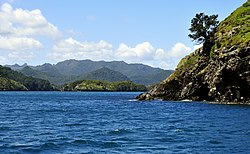
Eastern headland of the Mahurangi Harbour, and Scott Point, the headland of the Te Kapa Peninsula. Formerly a part of the Mahurangi Regional Park. |
| Mahurangi West Regional Park |
 |
Auckland Region |
1.00 |
1988[10] |
36.509°S 174.719°E / -36.509; 174.719 |
Western headland of the Mahurangi Harbour |
| Te Muri Regional Park |
 |
Auckland Region |
4.44 |
2010 |
36.519°S 174.706°E / -36.519; 174.706 |
Coastal park and farmland near Te Muri Beach. |
| Wenderholm Regional Park |
 |
Auckland Region |
1.49 |
1965 |
36.537°S 174.71°E / -36.537; 174.71 |
Coastal park between the Puhoi River and Waiwera River |
| Shakespear Regional Park |
 |
Auckland Region |
3.77 |
1967 |
36.608°S 174.823°E / -36.608; 174.823 |
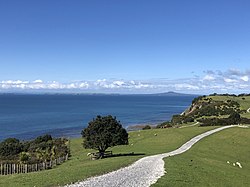
Coastal headland of the Whangaparāoa Peninsula, primarily farmland with areas of regenerating forest |
| Long Bay Regional Park |
 |
Auckland Region |
1.77 |
1970s |
36.675°S 174.745°E / -36.675; 174.745 |
Beach, sand dune and forested area to the north of the North Shore |
| Whakanewha Regional Park |
 |
Auckland Region |
2.47 |
2007 |
36.822°S 175.077°E / -36.822; 175.077 |
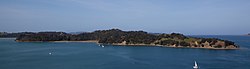
Coastal park on Waiheke Island |
| Muriwai Regional Park |
 |
Auckland Region |
4.36 |
1981 |
36.831°S 174.425°E / -36.831; 174.425 |
Coastal sand dune, wetland and golf course adjacent to Muriwai beach, featuring a mainland gannet colony |
| Motukorea Browns Island Regional Park |
 |
Auckland Region |
0.6 |
2018 |
36.831°S 174.895°E / -36.831; 174.895 |
Island in the Hauraki Gulf |
| Ōmana Regional Park |
 |
Auckland Region |
0.42 |
1970 |
36.881°S 175.023°E / -36.881; 175.023 |
Coastal park near Maraetai |
| Duder Regional Park |
 |
Auckland Region |
1.65 |
1995 |
36.906°S 175.084°E / -36.906; 175.084 |
Working farm and regenerating forest on the Whakakaiwhara Peninsula, east of Auckland |
| Mutukāroa / Hamlins Hill Regional Park |
 |
Auckland Region |
0.48 [11] |
1997[12] |
36.920°S 174.832°E / -36.920; 174.832 |
Working farm and regenerating native forest in Auckland |
| Waitawa Regional Park |
 |
Auckland Region |
1.88 |
2008 |
36.938°S 175.140°E / -36.938; 175.140 |
Coastal park and working farm to the west of Kawakawa Bay |
| Tawhitokino Regional Park |
 |
Auckland Region |
0.41 |
1981 |
36.944°S 175.211°E / -36.944; 175.211 |
Area adjacent to Tawhitokino beach |
| Ambury Regional Park |
 |
Auckland Region |
1.24 |
1987[13] |
36.948°S 174.766°E / -36.948; 174.766 |
A working sheep farm and bird sanctuary on the shores of the Manukau Harbour, Māngere Bridge. |
| Orere Point Regional Park |
 |
Auckland Region |
0.43 |
1981 |
36.956°S 175.231°E / -36.956; 175.231 |
Small forested and coastal park near Ōrere Point |
| Waitākere Ranges Regional Park |
 |
Auckland Region |
172.10 |
1964[A] |
36.967°S 174.517°E / -36.967; 174.517 |
Native bush and coastal park in the Waitākere Ranges |
| Tāpapakanga Regional Park |
|
Auckland Region |
2.47 |
1995 |
36.979°S 175.258°E / -36.979; 175.258 |
Coastal farmland and forested ares at the mouth of the Firth of Thames |
| Auckland Botanic Gardens |
 |
Auckland Region |
0.65 [14] |
1982[15] |
37.013°S 174.907°E / -37.013; 174.907 |
Botanical garden in Manurewa, South Auckland. While officially a regional park by the Auckland Council,[16] the botanic gardens are not managed under the regional park plan,[8] and does not incorporate the term 'regional park' into its name. |
| Waharau Regional Park |
 |
Waikato Region[B] |
1.69 |
1979 |
37.040°S 175.290°E / -37.040; 175.290 |
Park between the Hunua Ranges and Firth of Thames |
| Hunua Ranges Regional Park |
 |
Waikato Region, Auckland Region[C] |
178.42 [D] |
1965[E] |
37.07°S 175.18°E / -37.07; 175.18 |
Mountain range south-east of Auckland, featuring areas of native forest and water reserves |
| Whakatīwai Regional Park |
 |
Waikato Region[F] |
3.24 |
1967 |
37.073°S 175.28°E / -37.073; 175.28 |
Coastal park between the Hunua Ranges and the Firth of Thames |
| Āwhitu Regional Park |
 |
Auckland Region |
1.55 |
1975 |
37.094°S 174.651°E / -37.094; 174.651 |
Regional park composed of farmland, wetlands and regenerating forest on the eastern Āwhitu Peninsula |
| Papamoa Hills Regional Park |
 |
Bay of Plenty Region |
1.82 [19] |
2003[20] |
37.733°S 176.288°E / -37.733; 176.288 |
Native bush, open farmland and archaeological site southeast of Tauranga |
| Onekawa Te Mawhai Regional Park |
 |
Bay of Plenty Region |
3.62 [21] |
2010[22] |
37.990°S 177.167°E / -37.990; 177.167 |
Headland of the Ōhiwa Harbour in the Bay of Plenty Region |
|
| Tūtira Regional Park |
 |
Hawke's Bay |
4.64 [23] |
1999[G] |
39.234°S 176.893°E / -39.234; 176.893 |
A land use demonstration park between lakes Tutira and Waikopiro, with campgrounds and walking tracks. |
| Waitangi Regional Park |
 |
Hawke's Bay |
3 |
2000[23] |
39.564°S 176.924°E / -39.564; 176.924 |
5 km long coastal located between Awatoto and Haumoana, known for wildlife, sports and the Atea a Rangi star compass. |
| Pākōwhai Regional Park |
|
Hawke's Bay |
|
1973[23] |
39.603°S 176.870°E / -39.603; 176.870 |
The smallest of Hawke’s Bay’s regional parks. Popular for dog walking. |
| Pekapeka Regional Park |
 |
Hawke’s Bay |
0.98 |
1990s [23] |
39.721°S 176.768°E / -39.721; 176.768 |
One of the few remaining wetland areas in Hawke’s Bay, and a site of restoration. |
| Queen Elizabeth Park |
 |
Wellington Region |
6.38 |
1953 |
40.965°S 174.969°E / -40.965; 174.969 |
|
| Akatarawa Forest |
 |
Wellington Region |
155.00 |
|
41.041°S 175.037°E / -41.041; 175.037 |
Native forest north of Upper Hutt |
| Battle Hill Farm Forest Park |
 |
Wellington Region |
4.80 |
1987 |
41.060°S 174.940°E / -41.060; 174.940 |
|
| Kaitoke Regional Park |
 |
Wellington Region |
28.6 |
1983 |
41.069°S 175.199°E / -41.069; 175.199 |
|
| Pakuratahi Forest |
 |
Wellington Region |
80 |
|
41.141°S 175.161°E / -41.141; 175.161 |
|
| Belmont Regional Park |
 |
Wellington Region |
32.92 |
1986 |
41.190°S 174.875°E / -41.190; 174.875 |
|
| Wainuiomata Regional Park |
 |
Wellington Region |
3.40 |
2022[H] |
41.2792°S 174.9844°E / -41.2792; 174.9844 |
|
| East Harbour Regional Park |
 |
Wellington Region |
23.39 |
1979[6] |
41.29°S 174.91°E / -41.29; 174.91 |
Regional Park in three sections: the Northern Forest, an area southwest of Wainuiomata and east of the Wellington Harbour which includes the Butterfly Creek valley, Parangarahu Lakes Area, the area east of Pencarrow Head which includes Lake Kohangapiripiri and Lake Kohangatera, and Baring Head / Ōrua-pouanui |
| Ashley Rakahuri Regional Park |
 |
Canterbury Region |
4.17 |
2012[26] |
43.2816°S 172.5806°E / -43.2816; 172.5806 |
Banks of the Ashley River / Rakahuri and Okuku Rivers |
| Waimakariri River Regional Park |
 |
Canterbury Region |
150 |
2006[7] |
43.436°S 172.574°E / -43.436; 172.574 |
Banks of the Waimakariri River |
| Ferrymead Regional Park |
 |
Canterbury Region |
0.76 |
2018[27] |
43.566°S 172.702°E / -43.566; 172.702 |
On the southern banks of the Ōpāwaho / Heathcote River, surrounding Ferrymead Heritage Park |
| Lake Tekapo Regional Park |
 |
Canterbury Region |
1.65 |
2008 |
44.00°S 170.5°E / -44.00; 170.5 |
Eastern shores of Lake Tekapo |


.jpg)


.JPG)


.jpg)
.jpg)


.jpg)