Top Qs
Timeline
Chat
Perspective
River Tweed
River in the Scottish Borders and northern England From Wikipedia, the free encyclopedia

Remove ads
The River Tweed, or Tweed Water, is a river 97 miles (156 km)[1] long that flows east across the Border region in Scotland and northern England. Tweed cloth derives its name from its association with the River Tweed.[2] The Tweed is one of the great salmon rivers of Britain and the only river in England where an Environment Agency rod licence is not required for angling. The river generates a large income for the local borders region, attracting anglers from all around the world.[3]


Remove ads
Etymology
Tweed may represent an Old Brittonic name meaning "border".[4] A doubtful proposal is that the name is derived from a non-Celtic form of the Indo-European root *teuha- meaning "swell, grow powerful".[5]
Course

The River Tweed flows primarily through the scenic Borders region of Scotland. Eastwards from the settlements on opposing banks of Birgham and Carham it forms the historic boundary between Scotland and England.
It rises in the Lowther Hills at Tweed's Well near the rising points of the Clyde -- draining northwest (10 kilometres (6.2 mi) from the Tweed's Well) -- and the Annan, draining south (1.9 kilometres (1.2 mi) from the Tweed's Well).
"Annan, Tweed and Clyde rise oot the ae hillside" is a saying from the Border region.[6] East of Kelso, it becomes a section of the eastern part of the border. Entering England, its lower reaches are in Northumberland, where it enters the North Sea at Berwick-upon-Tweed. For only 7 kilometres of its course is it purely in England, and for 30 kilometres it is between England and Scotland.[7]
Remove ads
Catchment
The river east of St Boswells runs through a drumlin field. It is the relic of a paleo-ice stream that flowed through the area during the last glaciation. Major towns through which the Tweed flows include Innerleithen, Peebles, Galashiels, Melrose, Kelso, Coldstream and Berwick-upon-Tweed, where it flows into the North Sea. Tweed tributaries include:
- Whiteadder Water
- River Till
- Eden Water
- Teviot Water
- Leader Water
- Ettrick Water
- Yarrow Water
- Tima Water
- Gala Water
- Leithen Water
- Quair Water
- Eddleston Water
- Manor Water
- Lyne Water
- Holms Water
The upper parts of the catchment of the Tweed in Scotland form the area known as Tweeddale, part of which is protected as the Upper Tweeddale National Scenic Area, one of 40 such areas in Scotland which are defined so as to identify areas of exceptional scenery and to ensure its protection from inappropriate development.[8]
Management
Summarize
Perspective


Despite that the catchment straddles the border between Scotland and England, management of it – in terms of water quality, bio-security, and ultimately protection of the salmon of the River Tweed – is overseen by a single body, the River Tweed Commission.[9]
Remove ads
River Tweed Trail
As of 2024[update], work is in progress on the development of a 113-mile (182 km) walking and cycling route following the length of the river from Moffat to Berwick-on-Tweed. The work includes new sections of path, upgrades to existing paths, bridge replacement and repairs, pedestrian road crossings, lighting and signage. The path is expected to be completed during 2028.[10]
Gallery
 The River Tweed at Abbotsford, near Melrose
 The River Tweed from Mertoun House, near St Boswells
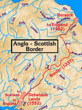 The Anglo-Scottish border, with the Tweed on the east. Its estuary and the town of Berwick-upon-Tweed were a late annexation by England.


See also
Notes
References
External links
Wikiwand - on
Seamless Wikipedia browsing. On steroids.
Remove ads