Top Qs
Timeline
Chat
Perspective
Romeoville, Illinois
Village in Illinois, United States From Wikipedia, the free encyclopedia
Remove ads
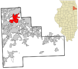
Romeoville is a village in Will County, Illinois, United States. The village is located 26 mi (42 km) southwest of Chicago on the Gateway Wetlands, directly west of the Des Plaines River and Historic U.S. Route 66 (now IL-53). Per the 2020 census, the population was 39,863.[4] Once a small river port, Romeoville experienced rapid growth in the 1990s and 2000s. It is located between Bolingbrook and Joliet near Interstate 55 and Interstate 355.
Remove ads
History
Summarize
Perspective

Romeoville was one of the last areas of Will County occupied by Native Americans. The village of Romeo was first settled on September 14, 1835, on Isle a La Cache, a small island in the Des Plaines River. Around this time, the first bridge was built to allow access to the island from the west bank of the river. In 1848, the I&M Canal was finished, drawing new residents to the area. On January 19, 1895, residents of Romeo voted to incorporate and changed the village's name to Romeoville. The community, along with nearby Joliet, became known as "Stone City" in reference to its prosperous limestone quarries. The Illinois State Capitol in Springfield was unveiled in 1888, and is constructed entirely of Romeoville limestone. Lewis University was established on the outskirts of town in 1934.
Romeoville is home to Citgo's Lemont Refinery. The refinery was constructed in 1922 across the river from the village. It was later the site of the 1984 Romeoville petroleum refinery disaster.
In 1950, Romeoville had approximately 46 homes and a population of 147. The village remained sparsely populated until 1957, when over 600 acres (240 ha) of wetlands along IL-53 became the Hampton Park Subdivision. An additional 400 acres (160 ha) were added in 1964, as Romeoville's population slowly grew. On October 5, 1990, the first interchange on I-55 and Weber Road was built, connecting the village to the rest of Chicagoland. Throughout the following decade, the area along Weber Road quickly became suburbanized as several new housing developments were completed. Romeoville was one of the fastest-growing communities in Illinois throughout the 1990s and 2000s. The population grew rapidly, and the village experienced an influx of over 25,000 new residents in two decades.[5]
Remove ads
Geography
According to the 2010 census, Romeoville has a total area of 18.759 square miles (48.59 km2), of which 18.44 square miles (47.76 km2), comprising 98.3%, is land and 0.319 square miles (0.83 km2), comprising 1.7%, is water. Romeoville borders the neighboring communities of Bolingbrook, Plainfield, Crystal Lawns, Crest Hill, Lockport and Lemont.[6]
Climate
Romeoville is home to a National Weather Service forecast office, although bulletins issued by said office begin, "The National Weather Service in Chicago..."[7]
Remove ads
Demographics
2020 census
Economy

Romeoville is home to over 600 businesses.[11] In 2013, the village won a Gold Medal from the International Economic Development Council and Atlas Integrated in the High Performance Economic Development category. They earned the award by creating 1,560 jobs during 2012–2013, which was the most for a town with a population between 25,001 and 100,000.[12]
Top employers
According to the village website,[13] the top employers in the village are:
Other major employers include Kehe Foods, FedEx Ground, and the Village of Romeoville.
Remove ads
Education
K–12 education
Romeoville residents attend the following schools:
Valley View School District 365U
- Valley View Early Childhood Center
- Beverly Skoff Elementary School
- Irene King Elementary School
- Kenneth L. Hermansen Elementary School
- Robert C. Hill Elementary School
- A. Vito Martinez Middle School
- John J. Lukancic Middle School
- Romeoville High School
- St. Andrew the Apostle School
Plainfield Community Consolidated School District 202
- Eichelberger Elementary School
- Creekside Elementary School
- Lakewood Falls Elementary School
- John F Kennedy Middle School
- Indian Trails Middle School
- Plainfield East High School
Higher education
- Joliet Junior College – Romeoville Campus
- Rasmussen College – Romeoville Campus
- Lewis University – Main Campus
Remove ads
Government
Mayors
Remove ads
Infrastructure
Transportation

- Metra station on the Heritage Corridor line.
- Lewis University Airport for basic aircraft to Boeing Business class.
- Pace bus route 834.
Major highways
Major highways in Romeoville include:
|
Interstate Highways |
US Highways |
Notable people
- Gerald Coleman, played goalie for the Lake Erie Monsters and Tampa Bay Lightning.
- Egotistico Fantastico, pro wrestler
- Oliver Gibson, DT, played with the Pittsburgh Steelers and the Cincinnati Bengals.
- Sandra Navarro Gillette, singer who charted a 1994 worldwide hit single, graduated from Romeoville High School.
- Antonio Morrison, LB, played with the Indianapolis Colts and Green Bay Packers.
- Byron Stingily, OT, played with the Tennessee Titans and Pittsburgh Steelers.
Remove ads
References
External links
Wikiwand - on
Seamless Wikipedia browsing. On steroids.
Remove ads


