Top Qs
Timeline
Chat
Perspective
Roughlee Booth
Civil parish in England From Wikipedia, the free encyclopedia

Remove ads
Roughlee Booth is a civil parish located in Pendle, Lancashire. It is approximately 449.43 hectares in size[2] and situated in the Forest of Bowland AONB.[3] It borders on the parishes of Blacko, Barrowford, Old Laund Booth, Goldshaw Booth and Barley-with-Wheatley Booth. It is part of the Forest of Bowland Area of Outstanding Natural Beauty (AONB).[4] It contains the village of Roughlee and hamlets of Crow Trees and Thornley Holme. According to the 2011 United Kingdom census, the parish has a population of 318,[1] a decrease from 328 in the 2001 census.[5]


Remove ads
Governance
Along with Higham-with-West Close Booth, Goldshaw Booth and Barley-with-Wheatley Booth, the parish forms the Higham with Pendleside ward of Pendle Borough Council.[6]
Roughlee Booth was once a township in the ancient parish of Whalley. This became a civil parish in 1866, forming part of the Burnley Rural District from 1894 until 1974. The village of Newchurch in Pendle used to straddle the boundary with Goldshaw Booth,[a] but that part of the parish was transferred in 1935.[8]
Remove ads
Media gallery
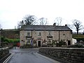 The Bay Horse public house in Roughlee village
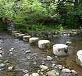 Stepping stones over Pendle Water near Roughlee Old Hall
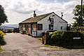 Noggarth Tea Gardens
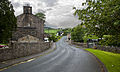 Thornley Holme, on the road to Barley
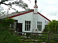 Clarion House, home of the Nelson Independent Labour Party Land Society
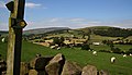 The Pendle Way passes through the parish
 Blacko Water in the east of the parish

.jpg)

.jpg)


.jpg)
See also
References
External links
Wikiwand - on
Seamless Wikipedia browsing. On steroids.
Remove ads