Top Qs
Timeline
Chat
Perspective
Saint-Ubalde
Municipality in Quebec, Canada From Wikipedia, the free encyclopedia

Remove ads
Saint-Ubalde (French pronunciation: [sɛ̃t‿ybald]) is a rural municipality in Portneuf County in the Canadian province of Quebec.
.svg)


Geographically its territory is marked by an agricultural and populated area in the south-west, and an undeveloped hilly area in the north-east.
Numerous watercourses and lakes (Blanc, Sainte-Anne, Ricard, Thom) crisscross and dot is entire territory.
The inhabited section is located in the southeast. Saint-Ubalde is centred on potato cultivation and outdoor recreation (canoeing, water skiing, fishing).[1]'.[4]
Remove ads
History
Saint-Ubald (originally without an "e") was founded by people from Neuville in 1860, and the Saint-Ubald Mission was established that same year. It was named after Ubald Gingras (1824-1874), first sacristan of the place but originally from Pointe-aux-Trembles (Portneuf), and who was brother-in-law of Charles-François Baillargeon, archbishop of Quebec. The mission became a parish in 1866 by separating from Saint-Casimir. In 1873, the civil parish was formed and incorporated as a parish municipality. A year later, its post office opened.[1]
In 1920, the village centre separated from the parish municipality to form the Village Municipality of Saint-Ubalde. But in 1973, the parish and village municipalities merged again to form the new Municipality of Saint-Ubalde.[1]
Remove ads
Demographics
Population trend:[5]
- Population in 2011: 1403 (2006 to 2011 population change: -3.8%)
- Population in 2006: 1458
- Population in 2001: 1460
- Population in 1996: 1540
- Population in 1991: 1552
Private dwellings occupied by usual residents: 646 (total dwellings: 1015)
Mother tongue:
- English as first language: 0%
- French as first language: 99.3%
- English and French as first language: 0%
- Other as first language: 0.7%
Remove ads
Photos
- St Paul-Street
 St-Paul & Commercial Street sign
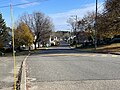 Heart of the municipality
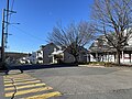 Typical street of rural village


- Some watercourses in St-Ubalde
 Rivière Blanche (Saint-Casimir)[broken anchor] bridge sign P-17644,[6] reinforced concrete gantry structure, rang Saint-Georges
 Rivière Blanche (Saint-Casimir) from P-17644, rang Saint-Georges
 Rivière Blanche (Saint-Casimir) from P-17644, rang Saint-Georges
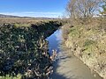 Rivière Charest, from Steel and Wood Bridge P-18620,[6] Bureau Road
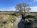 Rivière Charest, from Steel and Wood Bridge P-18620, Bureau Road
 Weller River (Stream), steel and wood bridge P-19613,[6] rang Saint-Joseph


See also
References
External links
Wikiwand - on
Seamless Wikipedia browsing. On steroids.
Remove ads