Top Qs
Timeline
Chat
Perspective
Sankrail
Census Town in West Bengal, India From Wikipedia, the free encyclopedia

Remove ads
Sankrail is a census town in Sankrail CD Block of Howrah Sadar subdivision in Howrah district in the Indian state of West Bengal.


Remove ads
Geography
Sankrail is located at 22.57°N 88.24°E.[1] It has an average elevation of 2 metres (6 feet).
Demographics
As per 2011 Census of India Sankrail had a total population of 29,114 of which 14,919 (51%) were males and 14,195 (49%) were females. Population below 6 years was 3,328. The total number of literates in Sankrail was 21,192 (82.18% of the population over 6 years).[2]
Sankrail was part of Kolkata Urban Agglomeration in 2011 census.[3]
As of 2001[update] India census,[4] Sankrail had a population of 25,590. Males constitute 54% of the population and females 46%. Sankrail has an average literacy rate of 64%, higher than the national average of 59.5%: male literacy is 69% and female literacy is 59%. In Sankrail, 12% of the population is under 6 years of age.
Remove ads
Transport
Munsirhat-Sankrail Road (Sankrail Station Road) is the artery of the town.
Bus
Private Bus
Mini Bus
Bus Routes Without Numbers
- Sankrail railway station - New Town Shapoorji Housing Estate
- Sankrail railway station - Sealdah Station (Barafkal)
Train
Sankrail railway station on Howrah-Kharagpur line serves the locality.
Gallery
 Bishalakhi Mandir, Sankrail
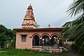 Shani Mandir (Jadu Nath Hati Smasana Complex), Sankrail
 Ramakrishna Mandir (Jadu Nath Hati Smasana Complex), Sankrail


References
Wikiwand - on
Seamless Wikipedia browsing. On steroids.
Remove ads