Top Qs
Timeline
Chat
Perspective
Santa Cruz, Manila
District of Manila From Wikipedia, the free encyclopedia

Remove ads
Santa Cruz is a district in the northern part of the City of Manila, Philippines, located on the right bank of the Pasig River near its mouth. It is bordered by the districts of Tondo, Binondo, Quiapo, and Sampaloc, as well as the areas of Grace Park and Barrio San José in Caloocan, and the district of La Loma in Quezon City. The district belongs to the 3rd congressional district of Manila.
.jpg)


Remove ads
History
Summarize
Perspective
Spanish colonial era

Prior to the arrival of the Spanish conquistadors to the Philippine archipelago in 1521, the district of Santa Cruz was partly marshland, patches of greenery, orchards, and ricefields. A Spanish expedition in 1581 claimed the territory and awarded it to the Society of Jesus.

The Jesuits then built the first Catholic church in the area, where the present Santa Cruz Church stands on June 20, 1619. The Jesuits enshrined the image of the Our Lady of The Pillar in 1643, and they served the area’s pre-dominantly Chinese residents. The image attracted devotees and a popular cultus grew around it
At Santa Cruz Church, a small park was built that connected the area to the headquarters of the Spanish cavalry, which once was the Jesuit-run Colegio de San Ildefonso. The district in Spanish times also had a slaughterhouse and meat market, and further north was the Chinese Cemetery.
On June 24, 1784, King Carlos III of Spain gave the deeds to about 2 km2 (0.77 sq mi) of land that was part of the Hacienda de Mayhaligue to San Lázaro Hospital, which served as the regional leprosarium. Franciscans were charged with caring for the lepers of the city, and Father Félix Huerta developed San Lázaro into a refuge for the afflicted on the north side of the Pasig River.
World War II
During World War II, the Japanese occupying forces, caught unaware of the fast-approaching joint American and Filipino soldiers from the north, abandoned the northern banks of the Pasig including the Santa Cruz area. The district and northern portions of Manila were spared from the heavy shelling which flattened the city, and to date, a number of pre-World War II buildings still stand in Santa Cruz.
When the Third Philippine Republic was proclaimed on July 4, 1946, the San Lázaro Hospital complex became the headquarters of the Department of Health.
Remove ads
Notable buildings


Santa Cruz Church
The first Santa Cruz Church was built when the Arrabal (Suburb) of Santa Cruz was established by the Jesuits in the early 1600s. The church had undergone many repairs and reconstruction, with the last reconstruction done in the 1950s. Today, the church architecture employs a California Spanish Mission style facade silhouette with the usual Filipino (Asian-Hispanic mix) Baroque ornamentation. The church facade is topped with an effigy statue of Our Lady of the Pillar, the patroness of the church whose feast happens every third Sunday of October and on the 12th day of October.
Cemeteries
Santa Cruz is home to Manila's oldest cemeteries located in the district's northern section namely, La Loma Cemetery (shared with Caloocan), the Manila Chinese Cemetery, and the city's biggest, the Manila North Cemetery.
Remove ads
Main thoroughfares

Rizal Avenue is the main thoroughfare in the district. The district is also accessible via the following roads:
Stations of the LRT Line 1 located in Santa Cruz are Carriedo (shared with Quiapo), Doroteo Jose, Bambang, Tayuman and Blumentritt (shared with Tondo). The Philippine National Railways has a station in Blumentritt. Jeepneys coming from Baclaran, Pasay, Valenzuela, Novaliches and Caloocan pass through Rizal Avenue.
Education
As of February 2024, the Manila Department of Education lists three senior high schools in Santa Cruz, namely Cayetano Arellano, Manuel L. Quezon (SHS) and Doña Teodora Alonzo.[2]
Barangays
Summarize
Perspective

Santa Cruz has 82 barangays, group in nine Zones of the City of Manila.
Sub-districts
Barangays
Santa Cruz has two postal codes corresponding to its two sub-districts: 1014 for Santa Cruz North[3] and 1003 for Santa Cruz South.[4]
Remove ads
Gallery
Religious buildings
 Santa Cruz Church
 San Roque Church
 Bethel Knox United Methodist Church


Civic institutions


Commercial establishments
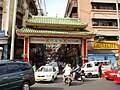 Chinatown (Plaza Santa Cruz), Third Welcome Gate (Arch of Goodwill) to Ongpin Street towards Binondo
 Ongpin Commercial Center
 Bank of the Philippine Islands at Don Román Santos Building, a neo-classical, Graeco-Roman structure at Plaza Goiti (now Plaza Lacson)
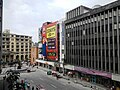 Carriedo Street with Plaza Lacson in the background
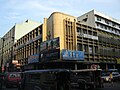 Commercial Buildings in Rizal Avenue
 San Lazaro Tourism and Business Park (formerly the San Lázaro Racetrack)
 Capitan Pepe Building


Residences
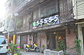 Bahay na bato house in Santa Cruz, Manila
 Bahay na bato apartments in Santa Cruz, Manila
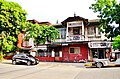 Period architecture in Santa Cruz, Manila
 Bahay na Bato House in Bambang Rizal Avenue


Remove ads
Notable
- Teodora Alonso Realonda, mother side of Dr. Jose Rizal
See also
References
External links
Wikiwand - on
Seamless Wikipedia browsing. On steroids.
Remove ads