Top Qs
Timeline
Chat
Perspective
Sarangkot
Subdivision of Pokhara in Gandaki Zone, Nepal From Wikipedia, the free encyclopedia

Remove ads
Sarangkot is Ward 18 of Pokhara, Kaski District, Nepal, after it was merged into the city in 2015. It is a popular tourist destination for those who arrive in Pokhara. At the 1991 Nepal census it had a total population of 5,060 with 1,010 individual households.[1]


The Ward is located on Sarangkot, a hill on the western side of Pokhara with an altitude of 1600m. Sarangkot is known for its panoramic Himalayan views of Dhaulagiri, Annapurna and Manaslu. It also provides an expansive view of the city of Pokhara, from the extreme north to the south including Phewa Lake. Tourists drive up the hill to watch the sunrise from the view tower at the top. In recent years, Sarangkot has been called one of the best paragliding locations in the world.[2][3] The hike up from the Pokhara Baglung highway at Miruwa to Sarangkot takes 90 minutes.[4]
Remove ads
Gallery
 View from Sarangkot
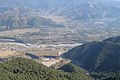 View from Sarangkot
 Pokhara Lake from Sarangkot
 Annapurna Himal from Sarangkot
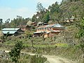
 Sarankot school
 Sarankot village
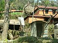
 Traditional houses


References
External links
Wikiwand - on
Seamless Wikipedia browsing. On steroids.
Remove ads