Top Qs
Timeline
Chat
Perspective
Sendai Subway
Metro system in Sendai, Japan From Wikipedia, the free encyclopedia
Remove ads
This article needs additional citations for verification. (June 2015) |
Sendai Subway | |||||||||||||||||||||||||||||||||||||||||||||||||||||||||||||||||||||||||||||||||||||||||||||||||||||||||||||||||||||||||||||||||||||||||||||||||||||||||||||||||||||||||||||||||||||||||||||||||
|---|---|---|---|---|---|---|---|---|---|---|---|---|---|---|---|---|---|---|---|---|---|---|---|---|---|---|---|---|---|---|---|---|---|---|---|---|---|---|---|---|---|---|---|---|---|---|---|---|---|---|---|---|---|---|---|---|---|---|---|---|---|---|---|---|---|---|---|---|---|---|---|---|---|---|---|---|---|---|---|---|---|---|---|---|---|---|---|---|---|---|---|---|---|---|---|---|---|---|---|---|---|---|---|---|---|---|---|---|---|---|---|---|---|---|---|---|---|---|---|---|---|---|---|---|---|---|---|---|---|---|---|---|---|---|---|---|---|---|---|---|---|---|---|---|---|---|---|---|---|---|---|---|---|---|---|---|---|---|---|---|---|---|---|---|---|---|---|---|---|---|---|---|---|---|---|---|---|---|---|---|---|---|---|---|---|---|---|---|---|---|---|---|---|
| |||||||||||||||||||||||||||||||||||||||||||||||||||||||||||||||||||||||||||||||||||||||||||||||||||||||||||||||||||||||||||||||||||||||||||||||||||||||||||||||||||||||||||||||||||||||||||||||||
| |||||||||||||||||||||||||||||||||||||||||||||||||||||||||||||||||||||||||||||||||||||||||||||||||||||||||||||||||||||||||||||||||||||||||||||||||||||||||||||||||||||||||||||||||||||||||||||||||
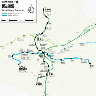
The Sendai Subway (仙台市地下鉄, Sendai-shi Chikatetsu) is a rapid transit system in Sendai, Japan. It is operated by the Sendai City Transportation Bureau. The subway consists of two lines, the north-south Namboku Line, which opened in July 1987, and the east-west Tozai Line, which opened in December 2015.[1]
The subway was damaged in the 11 March 2011 Tohoku earthquake and tsunami and shut down. It reopened on 29 April 2011.[2]
Remove ads
Lines
Rolling stock
- Sendai Subway 1000 series 4-car EMUs (Namboku Line, since July 1987)
- Sendai Subway 2000 series 4-car EMUs (Tozai Line, since December 2015)
- Sendai Subway 3000 series 4-car EMUs (Namboku Line, since 24 October 2024)[3]
Network Map
References
External links
Wikiwand - on
Seamless Wikipedia browsing. On steroids.
Remove ads


