Top Qs
Timeline
Chat
Perspective
Shyok River
River in India and Pakistan From Wikipedia, the free encyclopedia
Remove ads
The Shyok River (sometimes spelled Shayok) is a major tributary of the Indus River that flows through northern Ladakh in India and into Gilgit-Baltistan in Pakistan. Originating from the Rimo Glacier in the eastern Karakoram, it runs for about 550 km (340 mi) before joining the Indus near Skardu. Its basin, covering 33,465 km2 (12,921 sq mi), extends across three countries: India, Pakistan, and China. Its major tributaries include the Chip Chap, Galwan, Chang Chenmo, Nubra, and Hushe rivers.
Remove ads
Name and etymology
Summarize
Perspective
At least three hypotheses have been formulated regarding the origin of the river's name, Shyok, also spelled Shayok.
In 1854, Alexander Cunningham mentioned that the river took its name from the village of Shyok, which he spelled Shayok, located along its course,[2] but he did not substantiate this statement or provide etymological information about the village’s name.
In 1977, Friedrich A. Peter reported that Shyok was a misspelling of the Tibetan name Shayog (Wylie: sha-gyog; Tibetan: ཤ་གཡོག་). And he identified the name Shayog as being formed by the syllables shag (Tibetan: ཤག་, ‘gravel’) and gyog (Tibetan: གཡོག་, ‘to spread’) and meaning ‘gravel spreader’, alluding to the vast quantities of gravel deposited by the river floods.[3]
In 1992, Harish Kapadia observed that many geographical names along the historic trade route in the upper Shyok Valley were of Yarkandi origin, the Turkic dialect spoken by travellers from Yarkand in Central Asia. He interpreted Shyok as meaning ‘river of death’, from the Yarkandi sheo (‘death’), and related this interpretation to the river's deadly floods.[4]
The three hypotheses differ in their linguistic and historical contexts, and the sources cited do not allow for a clear preference among them.
Remove ads
Course
Summarize
Perspective
The Shyok originates at the snout of the Rimo Glacier, located in the union territory of Ladakh, India.[5][6][7] The glacier descends from the Rimo Massif, a group of peaks in the Rimo Muztagh subrange of the eastern Karakoram.[5][2] Near its source, the Shyok is joined from the northeast by the Chip Chap River, a tributary considered part of its headwaters system.[8][7][6]

The river flows initially southeastward, south-west of the Depsang Plains. Early in this stretch, it receives the Galwan River from the northeast.[8][9] Further downstream, it is joined by the Chang Chenmo River, from the east, and then encounters the Pangong Range.[9][5] There, it makes a broad V-shaped bend, reversing its direction to flow northwestward in a path nearly parallel to its initial course—a distinctive feature noted by several observers.[8][5]
Continuing northwest, the river flows past the village of Shyok and enters a broader valley where it meets the Nubra River, a major tributary fed by the Siachen Glacier.[5][2] The confluence occurs near the village of Lakjung, just northwest of Diskit.[10]

Beyond this confluence, the river narrows and cuts through a steep gorge a little upstream from the hamlet of Yagulung (also known as Changmar) before passing through the villages of Bogdang, Turtuk, and Tyakshi (also spelled Takshi).[5][10] Entering the administrative territory of Gilgit-Baltistan, Pakistan, the Shyok continues west-northwestward and receives the Hushe River in a widened area near the village of Ghursay.[11] Khaplu, the main settlement in the region, lies slightly downstream.[8]
The Shyok ultimately merges with the Indus River at the village of Keris, approximately 40 km (25 mi) southeast of Skardu.[2][8] The total length of the river from source to confluence with the Indus is estimated at approximately 550 km (340 mi).[12]
Remove ads
Tributaries
Summarize
Perspective
The Shyok drains a basin of about 33,465 km2 (12,921 sq mi), covering parts of the southeastern Karakoram and the western Aksai Chin region.[13] Upstream of its broad V-shaped bend near the Pangong Range, its main tributaries originate in western Aksai Chin and join from the east, on the left bank. Downstream of the bend, the principal tributaries enter from the north, on the right bank, draining the southeastern Karakoram.[6]

Upstream of the bend, the main left-bank tributaries include:
- The Chip Chap River, which rises at the eastern edge of the Depsang Plains, flows west, and joins the Shyok close to its glacial source.[8][7][6]
- The Galwan River, originating near the caravan camping ground of Samzungling in southern Aksai Chin, flows westward to meet the Shyok further downstream.[8][9]
- The Chang Chenmo River, which rises near the Lanak Pass at the southern edge of the Aksai Chin region, flows west, and merges with the Shyok close to its V-shaped bend.[9][5]
Downstream of the bend, the main right-bank tributaries are:
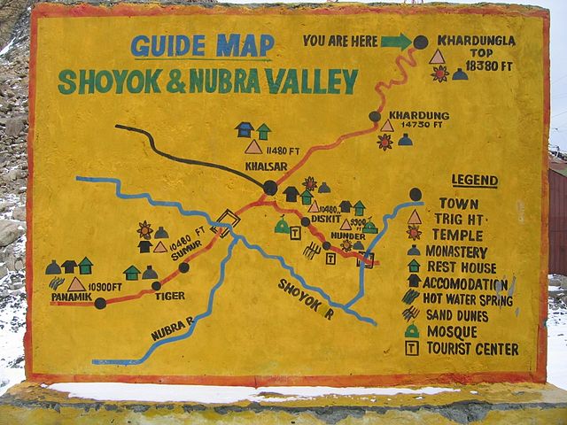
- The Nubra River, a glacial river fed primarily by the Siachen Glacier, flows southeast through the Nubra Valley and joins the Shyok near the village of Lakjung, just northwest of Diskit.[5][2][10]

- The Hushe River, sourced from the Gondogoro Glacier, is joined by the Saltoro River just before entering the Shyok near the village of Ghursay, close to Khaplu.[11][8] The Hushe and Saltoro Rivers drain the south face of the Masherbrum Mountains and the southwest face of the Saltoro Mountains.[11][7]
Geology
The Shyok flows through the geologically significant Shyok Suture Zone, a complex ophiolitic mélange representing a former Cretaceous–Paleogene back‑arc basin situated between the Kohistan–Ladakh arc and the Karakoram terrane.[14][15][16][17][18] The central portion of this suture comprises Jurassic fore‑arc ophiolite sequences overlain by Cretaceous volcanic and sedimentary rocks deposited under extensional tectonics between approximately 115 Ma and 72 Ma.[16][19][20][21] Within the mélange, pervasively deformed metasedimentary units and Paleozoic-era pebbly mudstones—interpreted as glacial‑marine deposits—are found, preserving Gondwanan signatures.[20][22][23][24] The region’s tectonic architecture is further imprinted by the active Karakoram fault system, which bisects the Shyok Valley and exhibits pronounced dextral-oblique shear fabrics affecting ophiolitic, granitic, and sedimentary lithologies.[14][15][23]
Remove ads
Valley
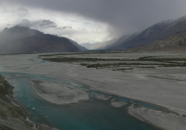
The Shyok flows through a rocky gorge carved into the Karakoram, with broad semiarid valleys in places that allow limited vegetation and agriculture.[12][24] The valley floor descends from 5,000 m (16,000 ft) at the snout of the Rimo Glacier to 2,314 m (7,592 ft) at the river’s confluence with the Indus at the village of Keris, near Skardu. In its lower reaches, seasonal meltwaters inundate the floodplain, supporting irrigated fruit orchards—apricots, walnuts, apples—and small villages.[12][25] During winter, the river often freezes solid, providing a natural passage between the Nubra Valley and Khaplu.[2][25]
Remove ads
History
Summarize
Perspective
During the 19th century, the Shyok and its valley became increasingly documented as part of British efforts to map the remote frontier regions of Ladakh and Baltistan.[26] Survey teams from the Survey of India—which conducted extensive frontier surveys following the Treaty of Amritsar (1846)—charted parts of the Shyok and its tributaries. These expeditions laid the groundwork for modern cartographic understanding of the western Himalaya and Karakoram ranges.[27]
The Shyok Valley also held historical significance as a segment of trade and travel routes connecting Leh with Baltistan and western Tibet. Caravans moving between Central Asia and the Indian subcontinent frequently navigated its upper reaches, making use of natural passes and riverine paths.[28][29][27][30] This strategic utility continued into the colonial period, when the British occasionally used these routes for communications and patrols along the mountain frontiers.

In the 20th and 21st centuries, the river has taken on renewed strategic importance due to its proximity to contested border zones—specifically near the Line of Actual Control (LAC) with China and the Line of Control (LoC) with Pakistan. Infrastructure such as the Darbuk–Shyok–Daulat Beg Oldi (DS–DBO) road has been built along the river’s banks, enhancing military logistics in the region adjacent to the Siachen Glacier and Aksai Chin.[31][32]
Remove ads
Tourism
The Shyok Valley provides access to the Nubra Valley, a popular destination in Ladakh. Key attractions along the Shyok include the sand dunes and Bactrian camel rides near the village of Hundar (also spelled Hunder), as well as the Diskit Monastery and its annual Diskit Gustor Festival.[33][34][35]
See also
References
Further reading
External links
Wikiwand - on
Seamless Wikipedia browsing. On steroids.
Remove ads


